
The GR131 Canary Islands: Map and Guide to All Seven Island Crossings
One waymarked route, seven islands, and how to choose the crossing that suits you
The GR131 is a single waymarked long-distance route running the length of the Canary Islands, from Órzola on the northern tip of Lanzarote to the Faro de Orchilla on the western tip of El Hierro. It covers roughly 560 km across 32 stages and forms part of the European E7 long-distance path, which is why the red and white flashes you follow here are the same ones used across the continent.
The GR131 is not one continuous walk. The islands are separated by open Atlantic, so each crossing is self-contained, joined to the next by a ferry rather than a path. Most people walk one island as a standalone trip, so the real planning question is not "how do I walk the GR131" but "which island should I walk".
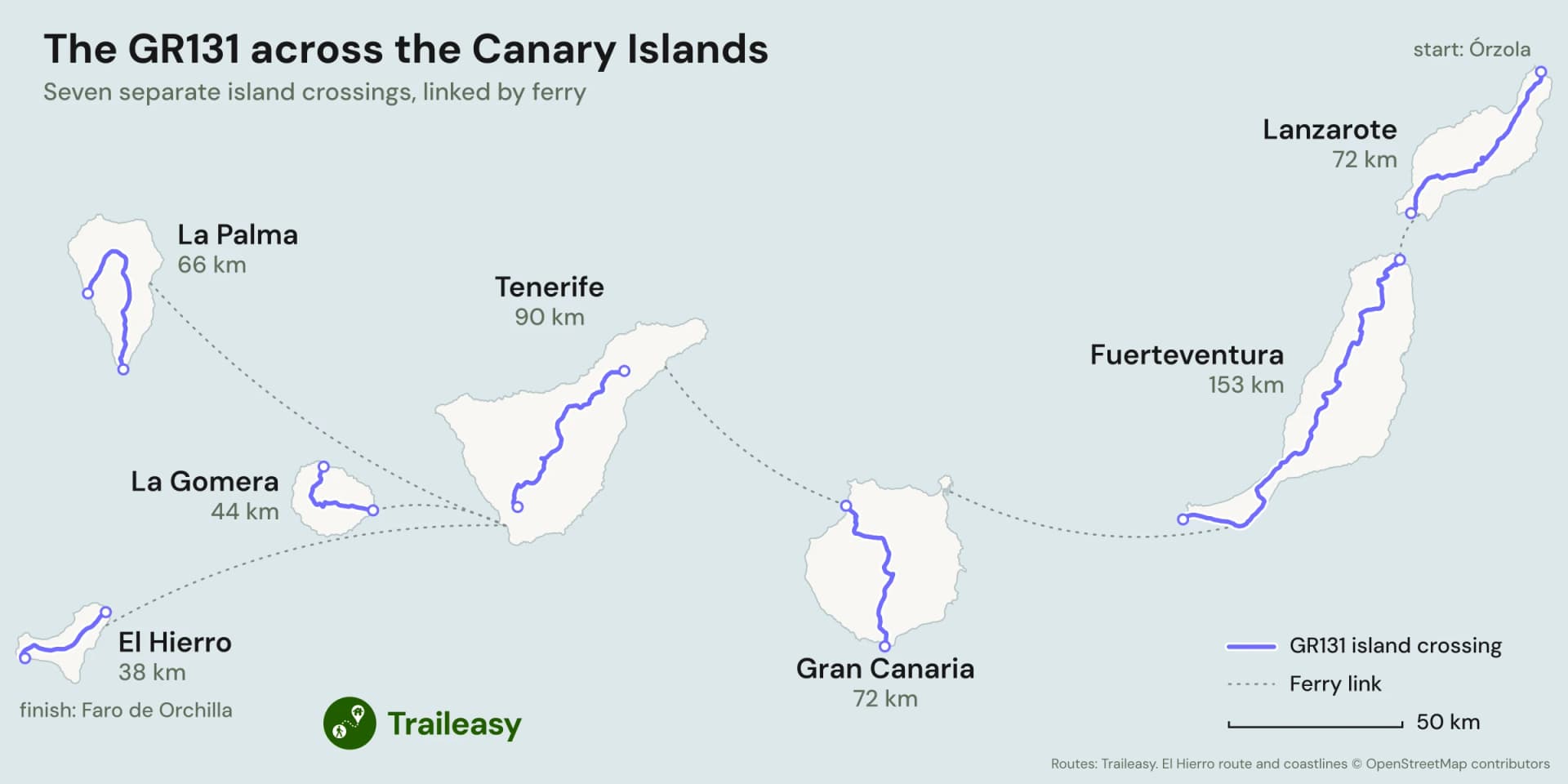
GR131 map: the seven island crossings, each island drawn to the same scale, from Órzola on Lanzarote to the Orchilla lighthouse on El Hierro, joined by ferry
All seven island crossings are covered below, and six come with an example day-by-day itinerary you can open and adapt: Lanzarote, Fuerteventura, Gran Canaria, Tenerife, La Gomera and La Palma.
The seven island crossings at a glance
| Island | Distance | Ascent | Typical days | Route |
|---|---|---|---|---|
| El Hierro | 38 km to | 1,600 m to | 2 to 3 | Tamaduste to Faro de Orchilla |
| La Gomera | 3 to 4 | San Sebastián to Vallehermoso | ||
| La Palma | 3 to 5 | Fuencaliente to Tazacorte | ||
| Lanzarote | 4 to 6 | Órzola to Playa Blanca | ||
| Gran Canaria | 4 to 6 | Maspalomas to Agaete | ||
| Tenerife | 5 to 7 | La Esperanza to Arona | ||
| Fuerteventura | 7 to 10 | Corralejo to Morro Jable |
Sorted by distance, the table makes its own point: length tells you almost nothing about difficulty here. La Palma is shorter than Lanzarote and climbs more than three times as much. Fuerteventura is more than twice the length of Gran Canaria and climbs considerably less. Read the ascent column before the distance column.
Which island should you walk?
Your first multi-day walk: Lanzarote. By a wide margin the gentlest of the seven, with a fraction of the climbing of the mountainous islands, moderate daily distances and a village to sleep in most nights. What makes it demanding is exposure rather than gradient, so it asks for sun discipline rather than hill fitness.
A long weekend: La Gomera. Three days end to end, and the only crossing that genuinely fits a short trip without feeling rushed. It is short and steep rather than short and easy, but you can fly in on a Friday and finish on a Monday.
The toughest: La Palma. More ascent packed into fewer days than anything else in the archipelago, running the volcanic spine of the island from a lighthouse at sea level to the observatories on the Roque de los Muchachos at 2426 m. Serious hill fitness required.
The highest: Tenerife. The only crossing where altitude is a genuine factor, spending days above 2,000 m along the Cumbre Dorsal before crossing the floor of the Las Cañadas caldera beneath Spain's highest mountain.
The longest and emptiest: Fuerteventura. Twice the length of most of the others, crossing open plains and the wild Jandía peninsula, with the water and accommodation logistics that implies. The one to walk if solitude is the point.
The best all-rounder: Gran Canaria. Coast to barranco to pine forest to coast in under a week, taking in Roque Nublo and Cruz de Tejeda, with more variety per day than any of the others.
Island by island
Lanzarote
The northernmost crossing and the one most people should start with. It runs the length of the island from the little harbour at Órzola, along the top of the Famara cliffs, then down through whitewashed villages, the palm valley at Haría, the old capital at Teguise and the lava vineyards of La Geria to Playa Blanca in the south. The ground is black and volcanic almost the whole way, and there is essentially no shade.
Five days works well, with days of 12.9, 13.5, 16.4, 17.6 and 16.3 km. The biggest climbing day gains only around , the most even profile of the six crossings, and each day finishes somewhere with a bed.
Full route detail, water sources and answers on camping, water and transport are on the GR131 Lanzarote trail page.
Fuerteventura
The long one. From the dunes at Corralejo the route runs the full spine of the island to Morro Jable in the far south, crossing the eroded volcanic massif around Betancuria and long open plains of stone and scrub. Officially it begins on Isla de Lobos, reached by a short boat trip, and ends at the lighthouse on Punta de Jandía well beyond Morro Jable, though most walkers treat Corralejo to Morro Jable as the crossing.
Eight days splits it sensibly: 26.2, 16.5, 17.3, 16.7, 27.3, 18.1, 14.2 and 20.3 km, through La Oliva, Tefía, Betancuria, Pájara, La Pared, Costa Calma and Jandía. Two of those days run past 26 km on ground with no shelter, which is what makes this crossing harder than its modest ascent suggests.
More on direction, water carrying and the route's true endpoints on the GR131 Fuerteventura trail page.
Gran Canaria
A south to north crossing that climbs from the Maspalomas lighthouse through deep barrancos into the mountainous heart of the island, past the monoliths of Roque Nublo and Roque Bentayga, then drops through the Tamadaba pine forest to the harbour at Puerto de las Nieves in Agaete. It shares most of its line with the Camino de Santiago de Gran Canaria, which continues to Gáldar instead of turning for the coast.
Five days gives 19.3, 11.9, 15.5, 7.2 and 20.1 km, overnighting at Ayagaures, Tunte, Cruz de Tejeda and Artenara. The numbers hide where the work is: day two and day three climb around and respectively, and the final day descends to the sea.
The pilgrimage connection, the Cabildo camping permit system and the direction question are covered on the GR131 Gran Canaria trail page.
Tenerife
Officially the Camino Natural Anaga-Chasna, running from La Esperanza along the Cumbre Dorsal ridge into the crater of Las Cañadas del Teide, across the lunar floor of the caldera, then down through Vilaflor and the pine forests above Ifonche to Arona. It passes beneath Spain's highest mountain rather than over it, and the summit is a separate permitted side trip.
Five official stages give 29.5, 15.2, 15.8, 16.1 and 16.7 km. Day one is the longest single day in the whole archipelago, 29.5 km for of ascent, and days two through four are spent high, where thinner air and cold nights matter more than the distances do.
National park rules, the Teide summit permit, altitude and the accommodation bottleneck inside the caldera are on the GR131 Tenerife trail page.
La Gomera
The shortest crossing, from the harbour at San Sebastián up through the laurel cloud forest of Garajonay National Park and down to Vallehermoso on the north coast. The forest is a relict of vegetation that once covered much of the Mediterranean, kept alive by cloud that the trade winds pile against the central massif, so expect the top of the island to be damp and misty while the coast is in sun.
Three days covers it: 14.5, 17.3 and 14.4 km. Day one climbs in 14.5 km, and the final day gives most of it back in one long descent.
Ferry logistics, the awkward accommodation situation and the GR132 circuit option are on the GR131 La Gomera trail page.
La Palma
Known locally as the Ruta del Bastón, after the walking-stick shape it traces on the map. It starts at the Fuencaliente lighthouse in the far south, climbs the crest of the Cumbre Vieja on the section known as the Ruta de los Volcanes, follows the rim of the Caldera de Taburiente to the Roque de los Muchachos, then hooks west and drops to the sea at Tazacorte.
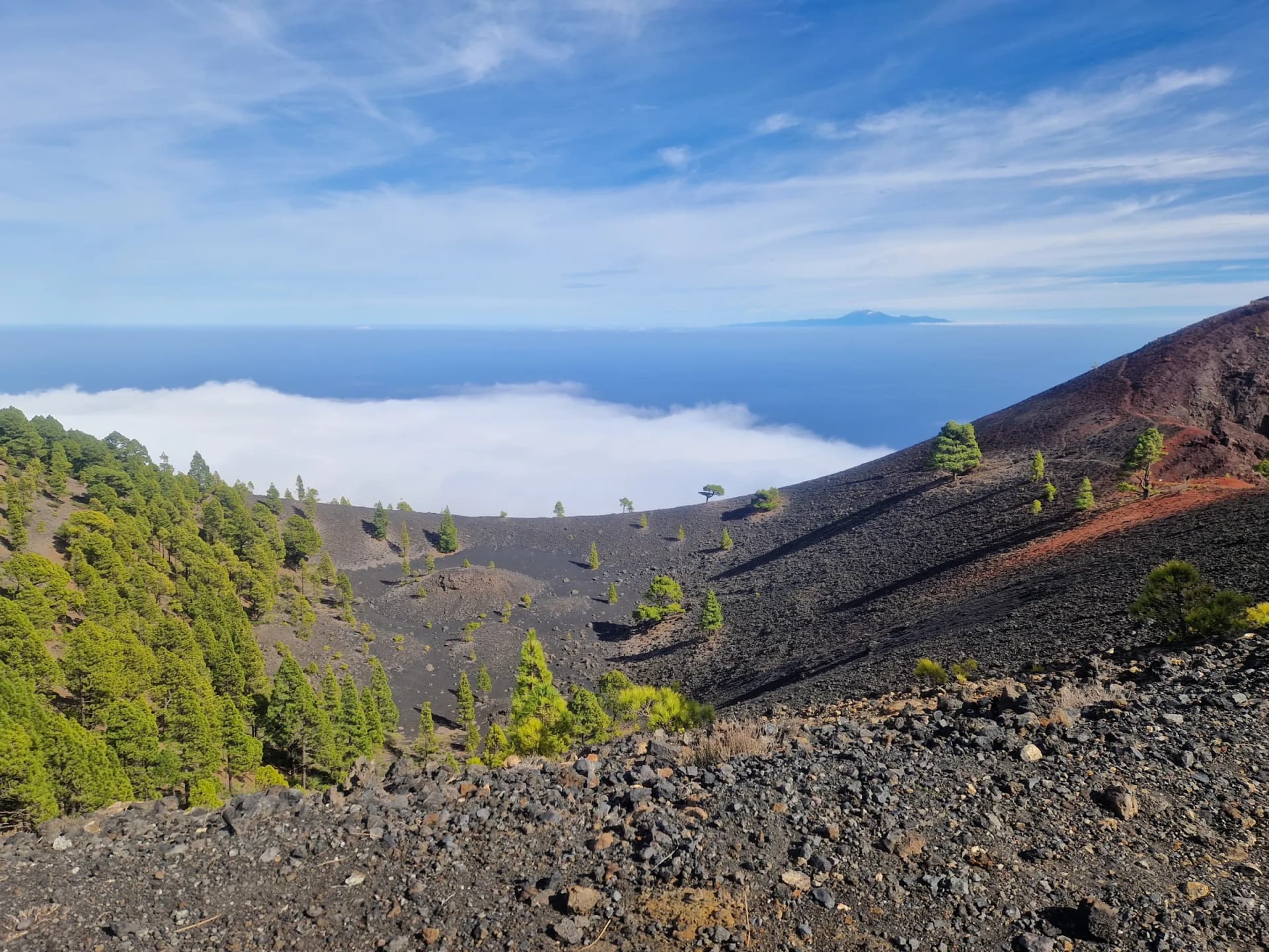
Teide seen across the sea from the Ruta de los Volcanes on La Palma
Four days is the comfortable split: 23.5, 12.4, 25.5 and 6.0 km. Day one gains , the single biggest climbing day anywhere on the GR131, and day three gives back on the way down. The two nights in the middle are spent at the Refugio del Pilar and the shelter at Punta de los Roques, because there is nothing commercial on the ridge at all.
The state of the route after the 2021 eruption, water on the ridge and how to break the crossing are on the GR131 La Palma trail page.
El Hierro
The last and smallest crossing, and the one island without a Traileasy trail page yet. It starts at Tamaduste on the northeast coast, or at the ferry port of Puerto de La Estaca, with the two starts meeting at the island capital Valverde. From there it climbs through San Andrés and the tree heath to Malpaso, the highest point on El Hierro at about 1,500 m, then descends past the Ermita de la Virgen de los Reyes to the Orchilla lighthouse on the western tip. Much of the line follows the Camino de la Virgen, the path of the procession that carries the island's patron from her shrine to Valverde every four years.
Sources put the crossing at 38 to 43 km with around 1,600 to 1,900 m of ascent, most of it on the way up from the coast. Two days is the usual split, or three at an easier pace. Orchilla is also the end of the whole GR131, marked by a monument to the old zero meridian. There is no village at the lighthouse and no bus, so arrange a taxi back in advance.
Getting between the islands
Ferries do the joining, and the network mirrors the route: services run broadly northeast to southwest along the chain, which is why the conventional direction starts on Lanzarote.
Playa Blanca at the southern tip of Lanzarote connects to Corralejo on Fuerteventura in well under an hour, several times a day, and it is the most convenient link in the archipelago because both ports sit directly on the trail. From the southern end of Fuerteventura, boats run from Morro Jable to Las Palmas on Gran Canaria in about two hours. Puerto de las Nieves in Agaete, where the Gran Canaria crossing finishes, has a fast service to Santa Cruz de Tenerife.
The western islands are reached from Los Cristianos in southern Tenerife rather than from Santa Cruz, which means crossing the island by road or bus. From Los Cristianos there are sailings to San Sebastián de La Gomera in around an hour, to La Palma in a few hours, and to El Hierro. La Gomera, La Palma and El Hierro have limited direct connections with each other, so most itineraries route back through Tenerife between them.
All the islands except La Gomera and El Hierro have airports with direct European flights, so a single-island trip usually needs no ferry at all. Timetables change with the season and services thin out considerably on Sundays, so check current schedules rather than planning around a fixed departure.
Planning any GR131 crossing
When to go
November to March is the season for the four lower crossings. Lanzarote, Fuerteventura, Gran Canaria and La Gomera are all comfortable to walk through winter, and summer on the open, shadeless ground of the eastern islands is genuinely unpleasant and at times unsafe.
Tenerife and La Palma invert that advice. Both spend days above 2,000 m where snow and ice are normal between December and March, park roads close when it settles, and an exposed ridge in cold wind is a serious proposition. For those two, late spring and early autumn generally give the best combination of open trails and manageable temperatures.
Calima, the Saharan dust that blows across from Africa, can arrive in any month on any island. It pushes temperatures up sharply and cuts visibility for a few days at a time, so a spare day in a longer itinerary is worth having.
Camping and permits
Wild camping is prohibited throughout the Canary Islands. Every island runs some form of authorised alternative, and the systems differ enough to be worth checking individually before you travel.
| Island | Position | Authorised option |
|---|---|---|
| Lanzarote | Prohibited outside authorised areas | Cabildo permit for designated grounds, plus a campsite near Papagayo |
| Fuerteventura | Not permitted, restricted outright in the Corralejo dunes and the Jandía natural park | Long gaps between beds mean many walkers camp discreetly regardless |
| Gran Canaria | Prohibited outside designated zones | Free Cabildo permit applied for online, with a category specifically for multi-day crossings on foot |
| Tenerife | Prohibited island-wide, including beaches and forests | Free online permit for recreational areas; inside Teide National Park, bivouac only in designated spots with authorisation |
| La Gomera | Prohibited, and enforced inside Garajonay National Park | The campsite at El Cedro |
| La Palma | Not permitted | The Refugio del Pilar and the shelter at Punta de los Roques |
Gran Canaria's scheme is the most organised of these and worth using rather than working around. Registering takes a little effort the first time, and permits generally cannot be requested more than a month ahead or later than a few days before.
Water
Plan on three litres a day as a baseline and four or five on the exposed southern stages of Fuerteventura. There are no streams or springs on any of these routes. Water comes from taps, bars and shops in the villages you pass, which makes the gaps between settlements the thing to plan around rather than the distance itself.
Three crossings make this a real constraint. Fuerteventura has the longest gaps and the driest ground. La Palma has nothing treated anywhere on the ridge, so a filter or purification tablets are standard rather than optional, and there is no food on the crossing either. Lanzarote has no natural water at all, though its villages are close enough together to make that manageable.
Waymarking and navigation
The GR131 is waymarked throughout with the red and white flashes used on GR routes across Europe, and signposting is generally good, with the mountainous islands better served than the open plains of Fuerteventura where features to hang a marker on are scarce. Junctions with local island paths are frequent and numbered separately, which is where most wrong turns happen.
Phone signal is patchy on the high crossings and disappears entirely inside the Teide caldera, so the route needs to work offline. The free Traileasy app holds whichever island crossing you plan and follows it without signal, and the same route exports as a GPX if you would rather carry it on a watch.
Accommodation
The crossings sit at opposite extremes of this. Lanzarote can be walked village to village with a bed every night. La Palma has nothing commercial on the ridge whatsoever, so it is either a tent and the refuges or a taxi down to a town and back up the next morning. The others fall in between, with one or two nights on each that constrain the whole itinerary: the parador at Cruz de Tejeda on Gran Canaria, the parador inside the caldera on Tenerife, and the middle stages on Fuerteventura where a day can end somewhere with nothing at all.
There are no staffed mountain huts anywhere on the GR131. Every night is a booking, the small guesthouses fill quickly between January and March, and on La Gomera in particular many are not listed on the usual booking sites and expect a direct enquiry and a two-night stay. Fix the constrained nights first and let the rest of the itinerary follow.
Walking the whole GR131
End to end, all seven islands take about a month including ferry days. The traverse traditionally closes on El Hierro at the Orchilla lighthouse, at what was once considered the end of the known world.
Walked as a continuous trip, the GR131 is an unusual thru-hike: seven distinct landscapes rather than one, with a boat and a resupply between each, and a difficulty profile that swings from flat volcanic plains to 2,400 m ridges and back. It is also entirely feasible in bite-sized pieces, and that is how nearly everyone does it. Start with one island, pick it from the table above, and come back for the next one.
Frequently asked questions
How long is the GR131 in the Canary Islands?
The full GR131 runs for roughly 560 km across 32 stages, linking seven islands from Órzola in the north of Lanzarote to the Orchilla lighthouse on the western tip of El Hierro. It is not one continuous path: each island carries its own self-contained crossing, and ferries join them together. The six crossings with a Traileasy trail page total just under 500 km on their own, ranging from 44 km on La Gomera to 153 km on Fuerteventura.
How many days does it take to walk the whole GR131?
Around a month for all seven islands, including the ferry days between them. Individual crossings are far more manageable and are how most people walk the route: two to three days on El Hierro, three to four on La Gomera, four to six on Lanzarote and Gran Canaria, three to five on La Palma, five to seven on Tenerife, and seven to ten on Fuerteventura. Walking one island as a standalone trip is the normal approach rather than a compromise.
Which Canary island has the best GR131 crossing?
It depends on what you want from the walk. Lanzarote is the gentlest and the best first multi-day hike, La Gomera fits into a long weekend, Gran Canaria offers the most variety in under a week, Tenerife takes you highest, La Palma is the toughest for its length, and Fuerteventura is the longest and emptiest. Gran Canaria is the strongest all-rounder for a first visit.
Can you camp on the GR131?
Wild camping is not permitted anywhere in the Canary Islands, but every island runs some form of authorised camping, and the systems differ considerably between them. Gran Canaria and Tenerife both operate free online permit schemes, Gran Canaria having a specific category for walkers crossing the island on foot over several days. On La Palma the two ridge refuges are the practical option, and on Lanzarote and La Gomera the crossings are short enough to walk without a tent at all.
Is the GR131 difficult?
Difficulty varies enormously between islands and does not track distance. La Palma climbs about 4,100 m in 66 km while Lanzarote climbs 1,300 m in 72 km, so the shorter crossing is by far the harder one. None of the route is technical and the paths are generally good, but heat, total lack of shade, loose volcanic ground and long gaps between water make several of the crossings tougher than the numbers suggest.
Do you need a permit or a guide for the GR131?
No guide is needed anywhere on the route, and the trail itself requires no permit on any island, including where it crosses Teide National Park and Garajonay National Park. Permits come into it only for camping, and for the separate side trip to the summit cone of Teide, which needs a free timed reservation booked in advance. Everything else is walk-up.