
Torres del Paine O Circuit
About Torres del Paine O Circuit
A full loop around the Paine massif, linking the remote, windswept back side of the range to the celebrated valleys of the W. It climbs to the John Gardner Pass for a sudden view over the vast Southern Patagonian Ice Field, then descends past the seracs of Grey Glacier, beneath the Cuernos and out to the granite towers themselves, through wild Patagonian country of turquoise lakes and roaming guanacos.
Torres del Paine O Circuit map
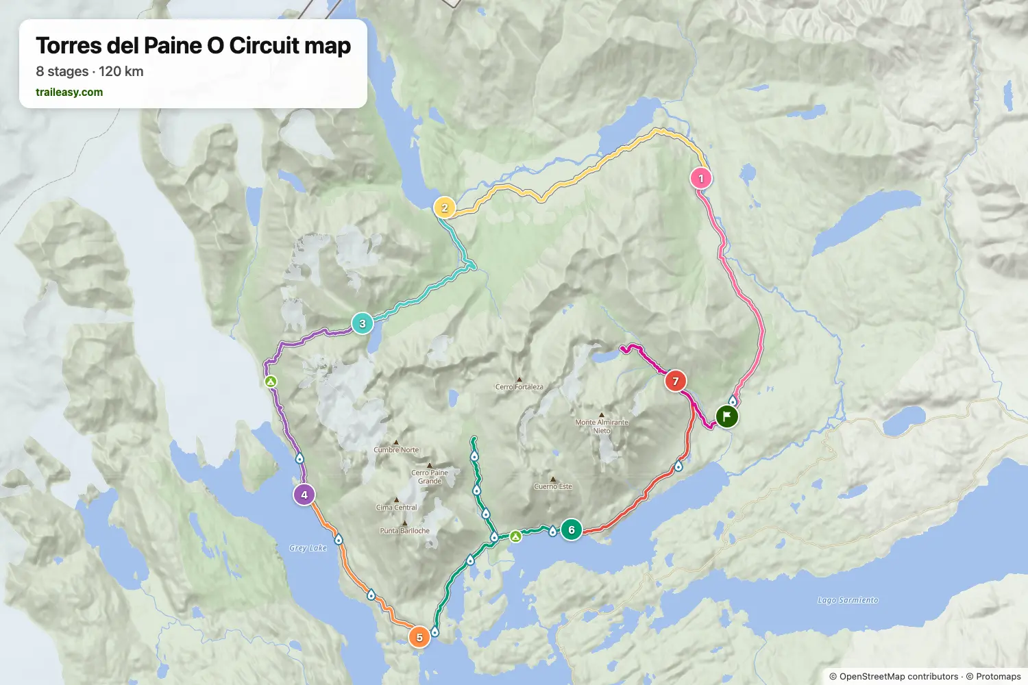
The interactive map shows the whole route, with accommodation, water and public transport along the way.
Torres del Paine O Circuit route planner
Build a day-by-day itinerary in the route planner, find accommodations along the route, and download the GPX file. Start from an example below or from scratch.
8-Day ItineraryShown below
The full counterclockwise loop of the Paine massif over eight days. From the Las Torres basecamp it climbs the quiet northern valleys to Serón and Lago Dickson, passes the hanging Los Perros glacier on the way up to the John Gardner Pass and its sudden view over the Southern Patagonian Ice Field, then drops beside Grey Glacier to join the classic W. The closing days trace Paine Grande, the Cuernos and the French Valley before a dawn ascent to the granite towers and the descent back to Las Torres.
Torres del Paine O Circuit stages
8 days, 119 km and 5,423 m of ascent. These stages follow the 8-Day Itinerary. Open it in the route planner to split or merge days and choose where you sleep.
- Stage 114.4 km↑ 370 m · ↓ 325 m ·
4–5h with stopsLas Torres Serón
Night at Campamento Seron - Stage 218.4 km↑ 583 m · ↓ 544 m ·
6–7h with stopsSerón Dickson
Night at Camping and Refugio Vertice Dickson - Stage 311.3 km↑ 529 m · ↓ 183 m ·
4–5h with stopsDickson Los Perros
Night at Campground Los Perros (Vertice) - Stage 415.0 km↑ 1,008 m · ↓ 1,491 m ·
6–7h with stopsFrom Los Perros
Night at Refugio Grey - Stage 510.7 km↑ 396 m · ↓ 427 m ·
3–4h with stopsTo Paine Grande
Night at Refugio & Camping Vertice Paine Grande - Stage 623.7 km↑ 1,028 m · ↓ 988 m ·
8–9h with stopsPaine Grande Los Cuernos
Night at Refugio Los Cuernos - Stage 712.3 km↑ 723 m · ↓ 397 m ·
4–5h with stopsLos Cuernos Chileno
Night at Refugio El Chileno - Stage 813.4 km↑ 786 m · ↓ 1,068 m ·
5–6h with stopsThe Towers & down Las Torres
Best time to go
- Best time1 Dec – 31 Mar
- Good time1 Nov – 30 Nov
The park authority closes the back of the circuit from April to October, so the full loop only runs in the southern summer, and CONAF publishes the current status of each sector. Every campsite must be booked for every night, and January and February sell out months ahead. November is windy with late snow possible on Paso John Gardner.
Frequently asked questions
What is the difference between the O Circuit and the W Trek, and which one should you choose?
The W and the O share the same famous valleys, but the O is the bigger trip. The W traces three arms on the southern face of the massif and takes four or five days. The O wraps the entire Paine massif in a single loop, adding the remote, little-walked back side before joining the W for its final stretch, and most people take seven to nine days over it. The other big difference is your pack. On the W the hardest climbs, such as the base of the towers, are usually done as day walks from a fixed camp, while on the O you carry everything with you the whole way round. Choose the W if you are shorter on time or want a first taste of Patagonia on well-serviced trails. Choose the O if you want solitude, the wild lenga forests and river valleys of the back side, and the moment you crest the John Gardner Pass to a sudden view over the Southern Patagonian Ice Field, and you are happy to commit to more days and a heavier load.
When is the best time to hike the O Circuit, and what is the weather like?
The season is short and runs from roughly November to late March, sometimes into early April. The back side of the loop opens later and closes earlier than the W, because the higher, more exposed ground around the John Gardner Pass needs the deep snow to clear and the small back-country camps only staff up for the core months, so the O has a narrower window. December to February is the warmest stretch with the longest daylight, and also the busiest and the windiest. Late November and March are quieter, and the autumn colour on the back side in March is superb, though services are thinner and the weather less settled. Whenever you go, expect Patagonia to serve all four seasons in a single day, with strong wind the near constant, so plan around the conditions rather than the calendar.
How do you get to the start of the O Circuit?
The gateway town is Puerto Natales, where the gear shops, supermarkets and trailhead buses are. Most people fly into Punta Arenas first and take a bus a few hours north to Puerto Natales. From there, daily buses run into Torres del Paine during the season and stop at Laguna Amarga, the entrance for the Las Torres sector where the O begins and ends. Because the loop is walked counter-clockwise, you set off north towards Seron rather than up to the towers, saving the towers for the very end. Buy your park entry ticket online in advance through the national park system, as it is checked when you arrive.
Do you need to book the campsites and refugios in advance, and how does booking the O work?
Yes, and it is the single biggest planning task for the O. Every night inside the park must be reserved before you arrive, whether you want a refugio bed, a serviced campsite or a pitch for your own tent, and wild camping is not allowed. The complication is that three different parties run the stops. Vertice Patagonia handles the back side and western camps such as Dickson, Los Perros, Grey and Paine Grande, Las Torres Patagonia, formerly Fantastico Sur, runs Seron and the eastern camps around Central, Chileno, Frances and Cuernos, and the park authority CONAF manages a couple of free, basic sites. Because the O runs one way, the real task is booking every night in the correct counter-clockwise order, with no gaps, across those separate systems. Reservations open a few months ahead of the season, often around April or May, and the scarce back-country nights such as Los Perros and Dickson go first, so book as early as you can. Traileasy's planner sets out your nights in walking order and shows which camp each day ends at and which of the parties to book it with, so you can line up the whole chain before the tight back-country nights are gone.
How many days do you need for the O Circuit, and why must you walk it counter-clockwise?
Most hikers take seven to nine days, with eight the common choice, and that pacing gives you slack for weather and for the longer days on the back side. The direction, though, is not a choice. The park requires the full circuit to be walked counter-clockwise, so you start north towards Seron and Dickson and approach the John Gardner Pass from Los Perros. The pass is crossed in that one direction for safety and to keep people moving on a steep, weather-exposed climb with an abrupt descent to Grey Glacier on the far side, and rangers check that you are travelling the right way and keeping to your booked camps. Walking it counter-clockwise also builds the trip towards its finale among the celebrated valleys of the W and the towers on your final morning.
How difficult is the O Circuit, and how fit do you need to be?
The O is a strenuous multi-day trek rather than a technical climb. There is no altitude to worry about and no scrambling, but the days are long and consecutive, you carry a full pack the whole way, and the John Gardner Pass day is a genuine test, with a sustained climb and a steep, rough descent to Grey Glacier. The back side is remote, so a bad-weather day out there is harder to bail out of than on the W. You do not need mountaineering skills or prior expedition experience, but you should be comfortably fit, able to walk day after day for many hours under a loaded pack, and ready for wind, rain and cold at any time. A few months of regular hills and back-to-back training walks before you go make the difference between enduring the O and enjoying it.
What should you pack for the O Circuit?
Pack for all four seasons, because you will meet them, and pack for more self-sufficiency than the W. The essentials are a windproof and waterproof shell, warm insulating layers even in summer, quick-drying base layers, sturdy broken-in boots, and a warm hat and gloves for the cold, exposed pass. Trekking poles help in the wind and on the steep descent from the pass, and strong sun protection matters when the Patagonian sun does appear. The back side has fewer places to top up supplies, so plan your food to carry further between stops, though water from the streams along the route is generally safe to drink and a refillable bottle saves weight. If you are camping and would rather not fly with a full kit, Puerto Natales has shops such as Erratic Rock where you can rent tents, sleeping bags and stoves.