
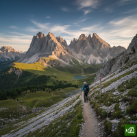
About Alta Via 1
The Alta Via 1 runs rifugio to rifugio south through the Dolomites, from Lago di Braies to a finish near Belluno, over the Sennes and Fanes plateaus, past the Lagazuoi and beneath Monte Pelmo and the Civetta. Its standard route has no via ferrata, only a few cabled handrails on exposed ground, making it the most accessible of the Dolomite high routes.
Alta Via 1 map
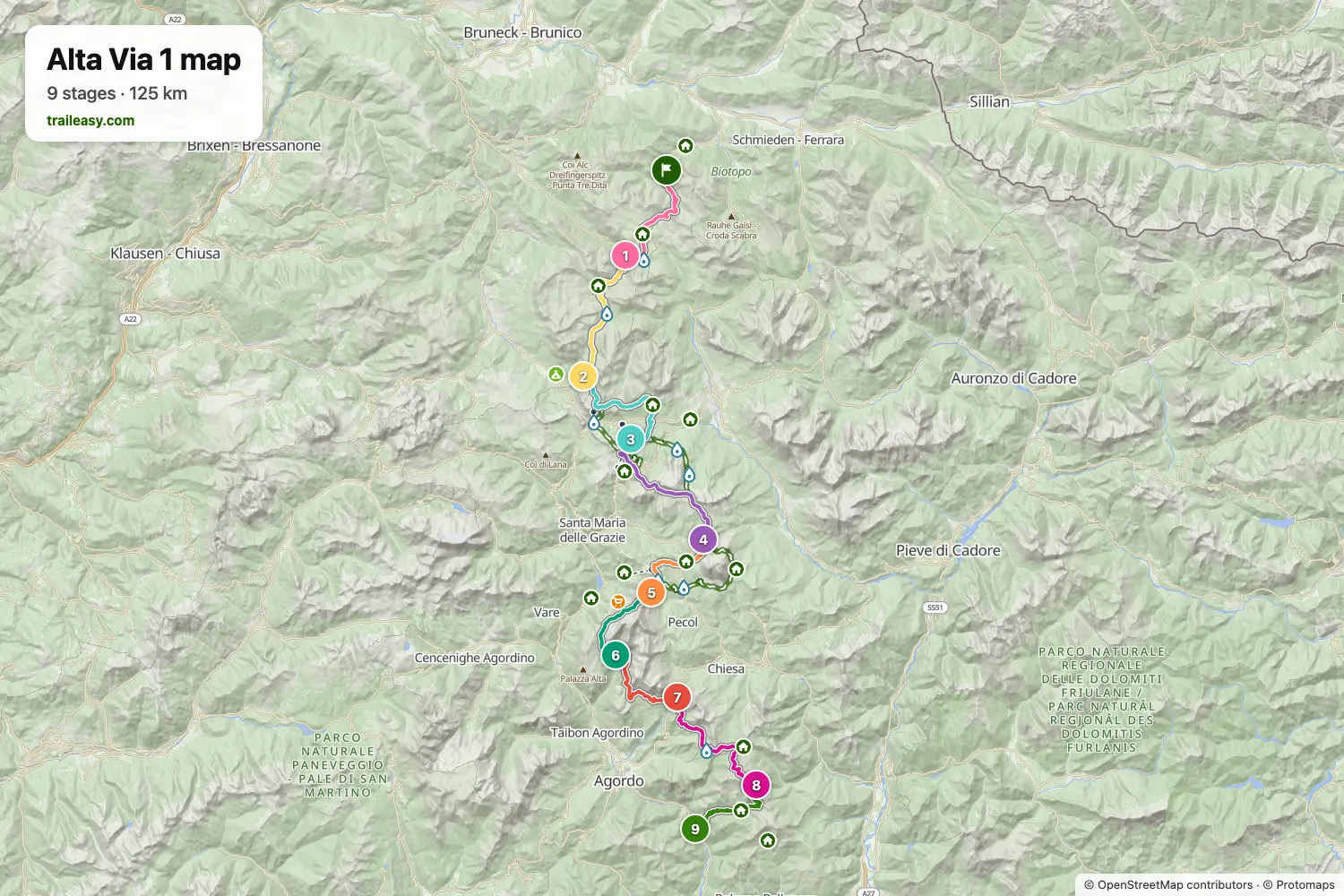
The interactive map shows the whole route, with accommodation, water and public transport along the way.
Alta Via 1 route planner
Build a day-by-day itinerary in the route planner, find accommodations along the route, and download the GPX file. Start from an example below or from scratch.
9 Day Hut to Hut ItineraryShown below
The classic Alta Via 1 route through the heart of the Dolomites. This 120km trek takes you from the emerald waters of Lago di Braies south through some of the most dramatic mountain scenery in the Alps, passing iconic peaks like the Tofane, Civetta, and the Schiara group. Stay in authentic rifugios along the way, experiencing traditional Italian mountain hospitality.
8 Day Hut to Hut
An 8-day itinerary that TallJoeHikes hiked in September 2025. It starts mildly from Lago di Braies up to Rifugio Biella and balances longer stages with shorter days. Overnights are at Biella, Fanes, Dibona, Nuvolau, Coldai, Vazzoler, and Pramperet, finishing at the La Pissa bus stop near Belluno.
What verified hikers say
Alta Via 1 stages
9 days, 119 km and 7,545 m of ascent. These stages follow the 9 Day Hut to Hut Itinerary. Open it in the route planner to split or merge days and choose where you sleep.
- Stage 114.2 km↑ 1,027 m · ↓ 980 m ·
6–7h with stopsLago di Braies Pederü
Night at Albergo Alpino Pederü Berggasthaus - Stage 215.4 km↑ 1,139 m · ↓ 693 m ·
6–7h with stopsPederü Rifugio Scotoni
Night at Rifugio Scotoni - San Cassiano Alta Badia - Stage 315.3 km↑ 1,286 m · ↓ 1,018 m ·
6–7h with stopsRifugio Scotoni Rifugio Scoiattoli
Night at Rifugio Scoiattoli - Stage 414.7 km↑ 685 m · ↓ 1,024 m ·
5–6h with stopsRifugio Scoiattoli Rifugio Città di Fiume
Night at Rifugio Città di Fiume - Stage 59.5 km↑ 628 m · ↓ 413 m ·
3–4h with stopsRifugio Città di Fiume Rifugio Coldai
Night at Rifugio Adolfo Sonino al Coldai - Stage 69.2 km↑ 401 m · ↓ 818 m ·
3–4h with stopsRifugio Coldai Rifugio Vazzoler
Night at Rifugio Mario Vazzoler - Stage 711.9 km↑ 722 m · ↓ 833 m ·
5–6h with stopsRifugio Vazzoler Passo Duran
Night at Rifugio Passo Duran "Cesare Tomè" - Stage 816.4 km↑ 1,214 m · ↓ 1,181 m ·
7–8h with stopsPasso Duran Rifugio Pian de Fontana
Night at Rifugio Pian de Fontana - Stage 912.3 km↑ 443 m · ↓ 1,617 m ·
5–6h with stopsRifugio Pian de Fontana La Pissa
Best time to go
- Best time1 Jul – 15 Sept
- Good time16 Jun – 30 Jun
- Possible, with care16 Sept – 30 Sept
The season runs from the middle of June to the middle of September, set by when the rifugios open and close. Late June can still hold snow on the high passes. July and August have every hut and bus running and are the busiest, with August filling months ahead, so book as soon as the huts open their season. From the middle of September huts close and some buses stop.
Frequently asked questions
How long is the Alta Via 1, and how many days do you need?
The Alta Via 1 runs about 120 km (75 miles) and most people walk it in 9 to 11 days. The standard route starts at the much-photographed Lago di Braies and finishes near Belluno at the La Pissa bus stop, and almost everyone walks it north to south to match the guidebooks and waymarking. The classic plan splits into around 11 rifugio to rifugio stages averaging 10 to 15 km, with steady daily climbing rather than big mileage. Strong hikers trim it to 6 or 7 days by linking stages or taking the odd bus or lift to skip ahead, while a more relaxed schedule leaves room for a rest day or a side summit. If you cannot spare close to two weeks, the trail also divides into shorter sections that stand on their own.
How far in advance should you book the rifugios?
Book as early as you can, ideally six to nine months ahead, because every night on the Alta Via 1 depends on a rifugio bed. Wild camping is not allowed in the Dolomites and there is only one campsite on the whole route, so there is no fallback if the huts are full. Most rifugios begin taking reservations for the next summer from around the previous September, though there is no shared date and each one sets its own, with a few not opening their books until February. The popular huts and the private rooms go first, so the safest approach is to settle your itinerary early, then book each hut the moment its dates open and fill any gaps later. Laying out your stages in the Traileasy planner first shows which rifugio each night needs, so you know exactly what to chase as the dates open. Cancellations do appear, so keep checking if a first choice is full, but treat early booking as part of the plan rather than an afterthought.
Can you wild camp on the Alta Via 1?
No. The Alta Via 1 runs through several protected nature parks, including Fanes-Sennes-Braies and the Dolomiti Bellunesi, where wild camping and bivouacking are banned outright, and the Dolomites as a whole take a firm line on it to protect the UNESCO landscape. Getting caught can mean a fine of roughly 100 to 500 euros. A single dusk to dawn bivouac, pitched after about 8pm and packed away by morning well away from any rifugio, is sometimes tolerated high up, but it is not something to rely on and a warden can move you on. There is also only one campsite on the whole route and very few others within reach, so unlike the Tour du Mont Blanc you cannot link together a tent-based itinerary. In practice the Alta Via 1 is a hut trek, and the few who do carry a tent still book rifugios or drop down to valley campgrounds rather than camp wild along the trail.
When is the best time to hike the Alta Via 1?
Mid June to mid September, and the rifugios set those dates more than the weather does. The stages on this route are spaced by where the huts are, so one hut closing early does not just cost you a bed, it breaks the itinerary either side of it. That matters most in the second half of September, when the huts stop on different dates rather than all at once. Check them one by one. Go in late June and you get flowers and space, with the trade that old snow can still sit in the north facing gullies below the passes. If your dates are fixed in August, build the route around the beds you can actually get rather than the other way round.
How difficult is the Alta Via 1, and do you need via ferrata experience?
The Alta Via 1 is the most accessible of the Dolomites high routes, and the standard trail involves no via ferrata, climbing, or scrambling, so you do not need technical experience to walk it. What it does ask for is solid hill fitness and a head for heights, since several stages cross steep, rocky, and exposed ground where steel cables are fixed as handrails for balance. The days are long and some stretches are remote with few easy escape routes, so you should be comfortable spending six hours or more on your feet in mountain weather that can change quickly. If you want more of a challenge, there are optional via ferrata detours along the way, though those need a helmet, harness, and lanyard, which you can hire in Cortina. For a fit hiker with a few mountain days behind them, the main route is demanding but very doable.
How do you get to the start, and back from the finish?
Getting to the Alta Via 1 takes some planning, since both ends sit away from the major transport hubs. Most hikers reach the start at Lago di Braies from Venice, travelling by train and bus through Cortina or Dobbiaco, which takes roughly five to seven hours over two or three connections. In peak summer the road to Lago di Braies closes to private cars during the day, so you need the public shuttle and should book it ahead. The trail finishes at the La Pissa bus stop, from where a short bus reaches Belluno and then a train or coach carries you back to Venice or onward. Because the two ends are far apart, sort your arrival and your return at the same time as your huts, since the seasonal buses and shuttles fill up and do not all run in the early or late shoulder.