
Walker's Haute Route
About Walker's Haute Route
Connecting Chamonix to Zermatt, this legendary high-altitude trek passes beneath ten of the twelve highest peaks in the Alps.
Walker's Haute Route map
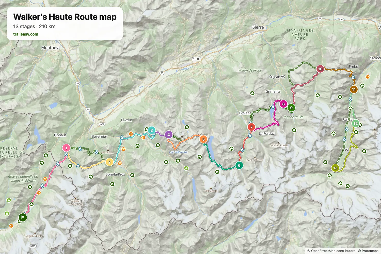
The interactive map shows the whole route, with accommodation, water and public transport along the way.
Walker's Haute Route route planner
Build a day-by-day itinerary in the route planner, find accommodations along the route, and download the GPX file. Start from an example below or from scratch.
13-Day ItineraryShown below
A 13-day traverse of the Walker's Haute Route, roughly 205 km from Chamonix to Zermatt via eight passes including the Fenêtre d'Arpette, Col du Tsaté and Augstbordpass. Two nights are spent at CAS huts (Cabane du Mont Fort, Cabane de Prafleuri), and the long stage over Col du Tsaté is split with an overnight at Cabane de Sorebois above Zinal to keep the daily distances reasonable. The final two days climb onto the Europaweg balcony trail for a straight-on view of the Matterhorn into Zermatt.
Walker's Haute Route stages
13 days, 209 km and 14,203 m of ascent. These stages follow the 13-Day Itinerary. Open it in the route planner to split or merge days and choose where you sleep.
- Stage 124.5 km↑ 1,433 m · ↓ 1,198 m ·
9–10h with stopsTo Trient
Night at The Auberge du Mont Blanc - Stage 215.1 km↑ 1,411 m · ↓ 1,217 m ·
7–8h with stopsTrient Champex-Lac
Night at Hôtel spa Au Club Alpin - Stage 322.1 km↑ 1,205 m · ↓ 1,149 m ·
8–9h with stopsChampex-Lac Verbier
Night at W Verbier - Stage 47.5 km↑ 930 m · ↓ 0 m ·
3–4h with stopsVerbier Cabane du Mont Fort
Night at Cabane Mont Fort - Stage 514.4 km↑ 1,063 m · ↓ 862 m ·
6–7h with stopsCabane du Mont Fort Cabane de Prafleuri
Night at Cabane de Prafleuri - Stage 617.3 km↑ 757 m · ↓ 1,343 m ·
6–7h with stopsCabane de Prafleuri Arolla
Night at Grand Hôtel & Kurhaus, Arolla - Stage 712.5 km↑ 559 m · ↓ 982 m ·
5–6h with stopsArolla La Sage
Night at Hôtel de la Sage - Boutique Hôtel - Stage 819.9 km↑ 2,029 m · ↓ 1,240 m ·
9–10h with stopsLa Sage Cabane de Sorebois
Night at Cabane de Sorebois - Stage 96.7 km↑ 4 m · ↓ 772 m ·
2–3h with stopsCabane de Sorebois Zinal
Night at Hôtel - Restaurant Europe - Stage 1017.3 km↑ 1,267 m · ↓ 1,106 m ·
7–8h with stopsZinal Gruben
Night at Hotel Schwarzhorn - Stage 1118.8 km↑ 1,167 m · ↓ 1,880 m ·
8–9h with stopsGruben St. Niklaus
Night at Hotel la Réserve - Stage 1211.4 km↑ 1,336 m · ↓ 189 m ·
5–6h with stopsSt. Niklaus Europahütte
Night at Europahütte Randa - Stage 1321.7 km↑ 1,042 m · ↓ 1,703 m ·
8–9h with stopsEuropahütte Zermatt
Best time to go
- Best time16 Jul – 15 Sept
- Possible, with care16 Jun – 15 Jul, 16 Sept – 30 Sept
Mid-July to mid-September is the most reliable window, when the high passes are clear and the huts are fully open. Huts start from the middle of June, but the Col de Riedmatten and the Pas de Chèvres ladders can hold snow into early July, and north-facing sections may need microspikes or an ice axe. From the second week of September cable cars and valley buses cut back and huts begin closing. Check each hut and lift for the year you walk.
Frequently asked questions
When is the best time of year to hike the Walker's Haute Route?
Mid July to mid September. The season here is really the overlap of three different calendars, and that is what catches people: the huts, the cable cars and the valley buses all run their own dates, and the lifts are usually the first to stop. A September itinerary that works on paper can fall apart because a lift you were counting on to skip a road section has finished for the year. At the early end the constraint is snow on the Col de Riedmatten and the Pas de Chèvres ladders, where north facing ground can still want microspikes into early July. Early September is the sweet spot if you check the lift dates first, with stable weather, thinner trails and the huts still fully staffed.
How many days does the Walker's Haute Route from Chamonix to Zermatt take?
The classic Walker's Haute Route itinerary runs 14 days, walking from Chamonix to Zermatt by way of Champex, Arolla, and Zinal. Most trekking guides split it into 14 daily stages covering around 200 to 220km with roughly 14,000 to 15,000m of cumulative ascent, so two weeks is the figure to plan around even before adding travel days at either end. Very fit hikers who skip a few short valley stages or use the occasional cable car can compress it to 10 or 11 days, while a more relaxed pace with a rest day in Arolla or Zinal stretches it to 15 or 16. If two weeks doesn't fit your schedule, the route also splits cleanly at Arolla into a western half from Chamonix and an eastern half into Zermatt, each doable in about a week on its own. Whichever length you pick, the Traileasy planner lays out the standard stages night by night, which makes it easy to see where a shorter or longer version actually saves or costs you a day. Budget one additional day on each end for getting to and from Chamonix and Zermatt, since neither is a quick hop from a major international airport.
How difficult is the Walker's Haute Route, and can a beginner do it?
The Walker's Haute Route is a genuinely tough trek and not the best choice for a first multi-day hike in the Alps. Most daily stages pair a long climb with a long descent, several passes sit higher than anything on comparable routes, and the descent from Pas de Chèvres uses a set of near-vertical metal ladders bolted into the rock, with nothing quite like it on gentler Alpine trails. The terrain between huts is often loose scree or unmarked moraine rather than a manicured path, so surefootedness and some prior experience with exposed alpine terrain matter more here than raw fitness alone. What tends to break hikers isn't any single day but the cumulative load of walking hard for 13 or 14 days in a row, so being able to repeat a long hill day with a big climb, several days running, without major fatigue is a better benchmark than a single training hike. If you're not sure you're ready, walking the easier eastern half on its own, or building up on a less demanding trail first, is a sensible way to test your legs before committing to the full route. The Traileasy planner includes several of the route's variants, Bovine among them, the usual gentler line when the Fenêtre d'Arpette is too much, so you can ease the toughest days without cutting the route short.
How does the Walker's Haute Route compare to the Tour du Mont Blanc?
The Walker's Haute Route is the harder and longer of the two treks. The TMB is a roughly 170km loop around the Mont Blanc massif through France, Italy, and Switzerland with daily climbs of about 600 to 1,000m, while the Haute Route runs point to point from Chamonix to Zermatt over 200km or more with steeper, longer days and terrain like the Pas de Chèvres ladders that has no real TMB equivalent. The two trails actually share ground for the first day or two out of Chamonix before the Haute Route splits off toward Switzerland's Val de Bagnes while the TMB loops back around the massif, so the early scenery looks familiar if you've done both. The TMB sees far more foot traffic and has more frequent valley towns with cafes and shops between passes, whereas the Haute Route feels more remote and its huts are more sparsely serviced. Many hikers treat the TMB as the natural first step, since it builds the hut-to-hut rhythm and mountain fitness the Haute Route then demands, and come back for the Haute Route a season or two later. If you're weighing which to do first, laying the two itineraries side by side day by day is the easiest way to see how much harder the Haute Route's days really are.
Should you hike the Walker's Haute Route from Chamonix to Zermatt or in reverse?
Chamonix to Zermatt, west to east, is the standard direction and the one almost every guidebook and published itinerary is built around. It also front-loads the trip sensibly: the western half between Chamonix and Arolla is rated the harder of the two, so walking it first means tackling the toughest terrain while you're freshest and still easing into the daily rhythm, then finishing on the comparatively gentler eastern half into Zermatt. Ending in Zermatt is also the more rewarding finish for most hikers, since the Matterhorn comes into view ahead of you on the final stages rather than disappearing behind you. Hiking east to west is technically possible and the paths are still walkable in reverse, but the waymarking and guidebook stage descriptions all assume the Chamonix start, so you'll be cross-referencing more and second-guessing junctions more often. Accommodation booking works the same either way, since huts don't care which direction you're walking, but transport planning is simpler if you fly into Geneva, start in Chamonix, and let the trek carry you toward Zermatt's train line at the end. Unless you have a specific reason to reverse it, such as ending your trip closer to Geneva, there's little upside to going against the grain.
How far in advance should you book huts and refuges on the Walker's Haute Route?
Start booking as early as each hut allows, ideally by February for a July or August hike. Many refuges open their booking calendars for the following summer sometime between October and January, though a handful, like Cabane de Moiry, don't open reservations until April. The calendar isn't uniform across the route, so each hut needs checking on its own. Peak season beds for July and August genuinely sell out months ahead, and popular huts near the passes fill faster than valley guesthouses, so lock your itinerary in once you start booking, since gaps are hard to fill later. Most huts take a deposit at the time of booking and settle the rest in cash when you arrive, so carry enough Swiss francs and euros for the stretches where card payment isn't reliable. Late June and September have more availability if your schedule is flexible, though even then the well-known huts on the western half book up faster than the quieter eastern stages. Booking windows and hut operators can change from year to year, so confirm current dates directly with each refuge rather than relying on last season's calendar.
How do you get to Chamonix and back from Zermatt?
Geneva is the standard gateway for both ends of the trip, since it's the nearest major international airport to Chamonix and well connected onward from Zermatt. From Geneva Airport, a direct bus or shuttle reaches Chamonix in about 1 hour 15 minutes to under 2 hours, while the train takes closer to 3.5 hours because of the connections through Annemasse and Saint-Gervais-les-Bains, so the bus is usually the easier choice for the outbound leg. Zermatt itself is car-free, so there's no drive-out option at the finish. You leave by the Matterhorn Gotthard Bahn down to Visp, then pick up the regular Swiss rail network back toward Geneva or on to Martigny for a connection to Chamonix, a return journey of roughly 4.5 to 5 hours door to door. Trains run frequently enough that you don't need to book the return leg far ahead, though it's worth checking the timetable the day before so you're not stuck waiting in Visp with a pack full of used hiking clothes. If you'd rather skip the return trip to Chamonix entirely, Zermatt's train line also connects easily onward to Bern, Geneva, or Milan for whatever comes next.