
Rob Roy Way
About Rob Roy Way
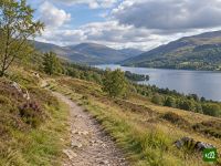
The Rob Roy Way crosses the southern Highlands from the Trossachs to Pitlochry, through the glens and lochsides that were Rob Roy MacGregor's country. Forest tracks, old railway paths and quiet lanes carry it past Loch Lubnaig, the Falls of Dochart and the length of Loch Tay.
Rob Roy Way map
The interactive map shows the whole route, with accommodation, water and public transport along the way.
Rob Roy Way route planner
Build a day-by-day itinerary in the route planner, find accommodations along the route, and download the GPX file. Start from an example below or from scratch.
7-Day ItineraryShown below
The official stage split of the Rob Roy Way, walked south to north from Drymen on the edge of Loch Lomond to Pitlochry. It runs through the Trossachs forests to Aberfoyle and Callander, follows the old railway line up Loch Lubnaig to Strathyre, climbs Glen Ogle and drops to Killin and the Falls of Dochart, then takes the quiet south shore of Loch Tay to Ardtalnaig before the River Tay carries it down to Aberfeldy and over the last hill to Pitlochry. Forest track, disused railway and single-track lane the whole way, with no summit to cross and a village at the end of nearly every stage — which is why this is one of the gentlest of Scotland's multi-day routes, and a common first long-distance walk.
Rob Roy Way stages
7 days, 129 km and 2,937 m of ascent. These stages follow the 7-Day Itinerary. Open it in the route planner to split or merge days and choose where you sleep.
- Stage 119.0 km↑ 335 m · ↓ 367 m ·
6–7h with stopsTo Aberfoyle
Night at Rob Roy Hotel - Stage 214.4 km↑ 361 m · ↓ 308 m ·
4–5h with stopsAberfoyle Callander
Night at The Crown Hotel - Stage 314.8 km↑ 196 m · ↓ 141 m ·
4–5h with stopsCallander Strathyre
Night at The White Stag Inn - Stage 422.0 km↑ 434 m · ↓ 438 m ·
7–8h with stopsStrathyre Killin
Night at The Falls Of Dochart Inn - Stage 521.0 km↑ 645 m · ↓ 609 m ·
7–8h with stopsKillin Ardtalnaig
Night at Bracken Lodges Loch Tay - Stage 623.1 km↑ 589 m · ↓ 660 m ·
7–8h with stopsArdtalnaig Aberfeldy
Night at Schiehallion Hotel - Stage 715.1 km↑ 377 m · ↓ 366 m ·
5–6h with stopsAberfeldy Pitlochry
Best time to go
- Best time1 Apr – 31 May, 1 Sept – 30 Sept
- Good time1 Mar – 31 Mar, 1 Jun – 31 Aug, 1 Oct – 31 Oct
- Possible, with care1 Nov – 29 Feb
Walkable in every month, low the whole way and rarely far from a road or a village. April, May and September have long daylight hours and no midges, which are out from June to August in the Loch Lubnaig forest and along the Loch Tay shore. Midwinter leaves six or seven hours of daylight for stages that fill a day, and snow settles on the Glen Ogle tracks and the moor above Aberfeldy. The Glen Quaich variant is shut in winter conditions.