
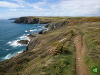
Pembrokeshire Coast Path
About Pembrokeshire Coast Path
The Pembrokeshire Coast Path follows the wild, cliff-top coastline of south-west Wales, from Amroth in the south to St Dogmaels in the north. It winds past sandy bays, rocky headlands and seabird colonies, passing the tiny cathedral city of St Davids along the way.
Pembrokeshire Coast Path map
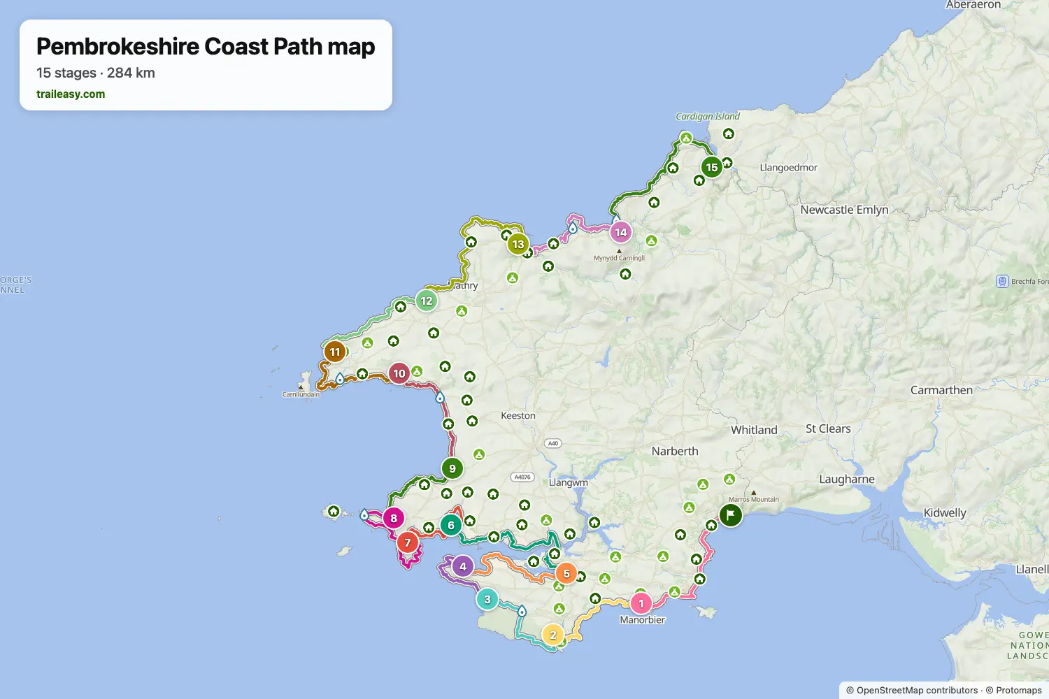
The interactive map shows the whole route, with accommodation, water and public transport along the way.
Pembrokeshire Coast Path route planner
Build a day-by-day itinerary in the route planner, find accommodations along the route, and download the GPX file. Start from an example below or from scratch.
15-Day ItineraryShown below
The classic end-to-end walk of the Pembrokeshire Coast Path, south to north from Amroth to St Dogmaels, following the National Trail's own division of the route into day sections. The opening days round the limestone cliffs and hidden bays of south Pembrokeshire past Manorbier, Barafundle and St Govan's chapel, then cross the Castlemartin range by Freshwater West to Angle and follow the Milford Haven waterway inland to Pembroke before returning to open coast at Sandy Haven and Dale. From the Marloes peninsula the route works north through Broad Haven and Solva to the tiny cathedral city of St Davids and the rock-strewn headlands beyond, then along a remote, seabird-loud clifftop by Trefin, Pwll Deri and Strumble Head to Fishguard, finishing over the moorland shoulder of Carningli and the high cliffs of Cemaes Head to the northern trailhead above the Teifi estuary.
Pembrokeshire Coast Path stages
15 days, 303 km and 8,835 m of ascent. These stages follow the 15-Day Itinerary. Open it in the route planner to split or merge days and choose where you sleep.
- Stage 122.7 km↑ 696 m · ↓ 674 m ·
7–8h with stopsAmroth Manorbier
Night at Castle Mead Hotel - Stage 218.1 km↑ 584 m · ↓ 579 m ·
6–7h with stopsManorbier Bosherston
Night at St. Govan's Inn - Stage 314.8 km↑ 104 m · ↓ 102 m ·
4–5h with stopsBosherston Freshwater West
Night at Gupton Farm Campsite - Stage 415.0 km↑ 347 m · ↓ 380 m ·
5–6h with stopsFreshwater West Angle
Night at Globe House - Stage 518.3 km↑ 346 m · ↓ 338 m ·
5–6h with stopsAngle Pembroke
Night at Old Kings Arms Hotel & Bar - Stage 626.0 km↑ 637 m · ↓ 638 m ·
8–9h with stopsPembroke Sandy Haven
Night at Sandy Haven Camping Park - Stage 715.8 km↑ 324 m · ↓ 328 m ·
5–6h with stopsSandy Haven Dale
Night at Broadside Bed & Breakfast - Stage 820.8 km↑ 459 m · ↓ 421 m ·
6–7h with stopsDale Marloes
Night at The Lobster Pot Inn - Stage 914.8 km↑ 473 m · ↓ 515 m ·
5–6h with stopsMarloes Broad Haven
Night at Anchor Guest House - Stage 1018.2 km↑ 684 m · ↓ 686 m ·
6–7h with stopsBroad Haven Solva
Night at The Cambrian Inn - Stage 1121.0 km↑ 524 m · ↓ 510 m ·
7–8h with stopsSolva Whitesands Bay
Night at Whitesands Camping - Stage 1219.9 km↑ 728 m · ↓ 692 m ·
7–8h with stopsWhitesands Bay Trefin
Night at The Old School Hostel - Stage 1330.0 km↑ 1,077 m · ↓ 1,111 m ·
10–11h with stopsTrefin Goodwick
Night at Glendower Hotel - Stage 1422.3 km↑ 750 m · ↓ 752 m ·
7–8h with stopsGoodwick Newport
Night at The Golden Lion Hotel - Stage 1525.5 km↑ 1,102 m · ↓ 1,096 m ·
9–10h with stopsNewport St Dogmaels
Best time to go
- Best time1 May – 30 Jun, 1 Sept – 30 Sept
- Good time1 Apr – 30 Apr, 1 Jul – 31 Aug, 1 Oct – 31 Oct
- Possible, with care1 Nov – 31 Mar
May, June and September are the best months on the cliffs, with settled spells, wildflowers and accommodation you can rely on. The puffins on Skomer are at their best from May to June, and grey seal pups appear on the hidden beaches from August, peaking into October. From November to March storms hit the exposed cliff tops and many campsites and services close.
Frequently asked questions
How long is the Pembrokeshire Coast Path and how hard is it?
The trail runs 186 miles (299 km) between Amroth in the south and St Dogmaels in the north. Most walkers take 12 to 15 days, covering roughly 15 miles a day on the classic schedule. No single day is mountainous, but the path constantly climbs in and out of steep coastal valleys, so the total ascent reaches about 35,000 ft (11,000 m). That is why it is often described as the equivalent of climbing Everest, and why walking the whole route is a genuine physical challenge even though individual sections feel gentle. Because the difficulty is really about that repeated climbing rather than any one summit, it pays to plan the days deliberately: setting the 186 miles out stage by stage on Traileasy shows how a tighter twelve day schedule piles on the ascent against a gentler fifteen, so you can pitch each day at your own legs rather than the guidebook default.
Should I walk south to north or north to south?
There is no official preferred direction, but most people walk south to north, from Amroth to St Dogmaels, and that is how the main guidebook is written. Starting in the south gives you a gentle introduction around Tenby and Saundersfoot, where cafes, pubs and accommodation are plentiful, and it saves the hardest, most remote stretch (Newport to St Dogmaels) for the end when you are fittest. The trade off is that the prevailing southwesterly wind and the sun tend to be in your face. Walking north to south puts the wind and sun more at your back but front loads the toughest, most exposed day.
Where do I sleep, and can I wild camp?
Wild camping is not legal in Wales without the landowner's permission, and the National Park is explicit that the private land the path crosses is not open to it. Instead, use the excellent network of official campsites, many of them right on the path, plus B&Bs, guesthouses, hostels and several YHA hostels along the route. Book ahead from April to October, especially in the peak summer months. Villages and towns are frequent in the south and centre for resupply, but note the northern section between Newport and St Dogmaels has no refreshments or services, so carry what you need for that day.
How do I get to the trail and back to my start by public transport?
The whole path is reachable by public transport. The West Wales railway serves Tenby, Saundersfoot, Manorbier, Pembroke and Pembroke Dock in the south, with Kilgetty the nearest station to Amroth. The northern end has no local station, so use Fishguard or the bus hub at Cardigan, with the Poppit Rocket bus reaching St Dogmaels and Poppit Sands. A dedicated network of coastal shuttle buses (the Poppit Rocket, Strumble Shuttle, Celtic Coaster, Puffin Shuttle and Coastal Cruiser) links the trailheads and lets you return to your start, mostly running daily from May to September. Check current timetables with Traveline Cymru before you travel, as routes and frequencies change seasonally.
Are there tidal crossings or hazards I need to plan around?
Two tidal crossings near Dale must be timed with the tide. Sandy Haven Pill is reliably passable only about three hours either side of low water, and The Gann a little less, so aim to reach the first crossing around three hours before low tide to clear both, or face detours of several miles. Always check a tide table. Separately, the Castlemartin firing range in the south (which includes the Green Bridge of Wales and St Govan's Chapel) closes the coast path during live military firing, so check the published firing notices and follow the inland range trail when red flags are flying. Keep well back from crumbling cliff edges throughout, and carry water, as refill points along the path are limited.
What are the must-see highlights along the way?
The path strings together some of Britain's finest coastal scenery. Do not miss St Davids, the smallest city in the country, with its ancient cathedral, and the seabird islands of Skomer and Skokholm, reached by boat from Martin's Haven and famous for puffins and seals. Look out for the Green Bridge of Wales, a spectacular natural limestone arch, the tiny cliff-wedged St Govan's Chapel, and the golden sands of Marloes, Barafundle and Whitesands. Strumble Head in the far north is a fine spot for seals and porpoises, and in autumn you can watch grey seal pups on quiet beaches from the clifftops.