
Hardangervidda Crossing
Also known as Hardangervidda på tvers or Hardangerviddatraversen
About Hardangervidda Crossing
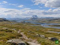
A hut to hut crossing of northern Europe's largest mountain plateau, from the railway outpost of Finse to the old travellers' inn at Haukeliseter. Treeless and wide open, the route threads countless lakes and the landmark dome of Hårteigen, through the range of Europe's last great herd of wild reindeer.
Hardangervidda Crossing map
The interactive map shows the whole route, with accommodation, water and public transport along the way.
Hardangervidda Crossing route planner
Build a day-by-day itinerary in the route planner, find accommodations along the route, and download the GPX file. Start from an example below or from scratch.
6-Day ItineraryShown below
The DNT hut chain across Hardangervidda, from the railway station at Finse to the mountain lodge at Haukeliseter on the E134. Five of the six nights are at Turistforening huts and one at the privately run Stigstuv: Krækkja, Stigstuv, Sandhaug and Litlos are staffed with full service, Hellevassbu is self-service with provisions to buy, and Haukeliseter is a staffed lodge on the road at the far side of the plateau. The route stays on the open vidda the whole way, among lakes and wide moorland, passing the dome of Hårteigen on the way to Litlos.
Hardangervidda Crossing stages
6 days, 126 km and 2,442 m of ascent. These stages follow the 6-Day Itinerary. Open it in the route planner to split or merge days and choose where you sleep.
- Stage 123.7 km↑ 451 m · ↓ 517 m ·
7–8h with stopsTo Krækkja
Night at Krækkja - Stage 219.7 km↑ 475 m · ↓ 395 m ·
6–7h with stopsKrækkja Stigstuv
Night at Stigstuv - Stage 320.2 km↑ 280 m · ↓ 264 m ·
6–7h with stopsStigstuv Sandhaug
Night at Sandhaug - Stage 424.8 km↑ 407 m · ↓ 463 m ·
7–8h with stopsSandhaug Litlos
Night at Litlos - Stage 516.5 km↑ 460 m · ↓ 489 m ·
5–6h with stopsLitlos Hellevassbu
Night at Hellevassbu - Stage 621.3 km↑ 369 m · ↓ 550 m ·
6–7h with stopsHellevassbu Haukeliseter
Best time to go
- Best time16 Jul – 15 Aug
- Good time1 Jul – 15 Jul
- Possible, with care16 Aug – 15 Sept
Best from the second half of July to the middle of August, when every hut is open. The DNT summer bridges go out at the start of July, while snow is still melting and the rivers run high. Stigstuv, the one private hut, closes in the middle of August, leaving a very long day or a tent before Sandhaug, and in early September Krækkja shuts and Sandhaug and Litlos switch to self-service on the DNT key. The bridges are taken down during September.
Frequently asked questions
Can you hike across Hardangervidda in June or September?
June is too early for the hut to hut crossing, and September works only with a changed plan. In June the plateau is still coming out of winter, with snow on the higher ground and rivers full of meltwater. The DNT summer bridges over the bigger streams go out only at the start of the summer season, and snow, floods or a shortage of volunteers can delay them. Several huts on the line also stay shut through the spring, partly to leave the wild reindeer undisturbed while they calve. September has the opposite problem. The weather can still be good, but the huts drop out: Stigstuv, which is privately run, closes earlier than the DNT huts, Krækkja shuts completely since it has no self-service room, and Sandhaug and Litlos fall back to self-service on the DNT key. As the month goes on the bridges are taken in, and on an open, treeless plateau winter can arrive early.
How many days does the Hardangervidda crossing take, and should you walk it north to south?
Plan on six days, sleeping at a hut every night: from Finse to Krækkja, Stigstuv, Sandhaug, Litlos, Hellevassbu and on to Haukeliseter. None of the climbs is big, but each stage fills a full day on rough ground, so merging two makes for a very long one. A seventh or eighth day gives you room to wait out fog or rain at a hut, or to take a rest day. North to south is the usual direction. Finse has no road, so you arrive by train and step straight onto the plateau, and you finish at Haukeliseter, a lodge on the E134 with daily express buses toward Oslo, Bergen and Haugesund. It is also the way DNT's long MASSIV route runs, ending at Haukeliseter. Walking it the other way works just as well, and then the train from Finse takes you home.
How hard is the Hardangervidda crossing, and is the route waymarked?
It is demanding rather than technical. No single climb is big, but every stage is a full day over stony, uneven ground and wet bog, with plank walkways laid across the softest stretches. Yes, it is marked. DNT marks its summer routes with small cairns, some of them painted with a red T, because red still shows in fog and grey weather. The winter ski routes are marked in red as well, and DNT warns that following winter marking in summer can lead you into bogs. DNT's own advice is that no marking replaces the ability to navigate, and that counts most when cloud sits on the plateau. The free Traileasy app works offline, so out on the open vidda, with the next cairn lost in the cloud, it still shows where you are on the route you planned; export the same route as a GPX if you would rather follow it on a watch.
Do you need to book the huts on Hardangervidda, and do you need a DNT membership or key?
You can book most of the huts, and membership only matters at the self-service one. Krækkja, Sandhaug and Litlos are staffed DNT huts serving meals, as are Finsehytta at the start and Haukeliseter at the finish. They take reservations through DNT's online booking but hold back some beds for walkers who turn up, and if every bed is taken you will in most cases still get a mattress. Stigstuv is the exception: it is privately run, books by email only, and offers neither beds nor food outside its own season. Hellevassbu is a self-service hut, locked with the DNT key and stocked with provisions you pay for in the DNT app. The key is lent only to DNT members against a small deposit, from DNT's offices, its online shop or a staffed DNT hut, and at least one person in your group must be a member. Non-members can stay at the staffed huts, though members pay less.
How do you get to Finse, and how do you get away from Haukeliseter?
By train to Finse and by bus from Haukeliseter. Finse has no public road. It sits on the Bergen Line between Oslo and Bergen, Vy's trains from both cities stop there, and Finsehytta, where the crossing starts, is easy to reach from the station. Haukeliseter is a mountain lodge right on the E134 over Haukelifjell, a road kept open all year. The Haukeliekspressen buses stop outside its main entrance, with daily departures toward Oslo, Bergen and Haugesund and connections on to Kristiansand and Stavanger. If you are driving, leave the car at Haukeliseter, since Finse cannot be reached by road, and take the bus and then the train round to the start.
Do you need a permit to hike or wild camp on Hardangervidda?
No. Norway's Outdoor Recreation Act lets anyone travel on foot through uncultivated land in every season, and the Hardangervidda National Park regulations ask individual walkers for no permit. The same right lets you camp. Pitch at least 150 metres from any inhabited house or cabin, and do not stay more than two nights in one place without the landowner's consent, a limit that does not apply high in the mountains or far from settlements. A tent is worth carrying even on this hut route, since it gets you from Krækkja to Sandhaug when Stigstuv, the one private hut, is closed. Inside the park, dogs must not be let loose, and organised groups can be required to get a permit. The rules also protect wildlife from disturbance in the breeding season, so keep well away from the wild reindeer and never follow them for a photo.
Can you drink the water from streams and lakes on Hardangervidda?
There is water almost everywhere on the plateau, but the Norwegian Institute of Public Health (FHI) advises boiling any water taken straight from nature. Clear water can still carry bacteria, viruses and parasites that cause stomach infections. Between the huts you refill from streams and lakes. For choosing where, FHI's advice is running, clear water with no smell or taste, away from animal droppings, dead animals such as lemmings, and grazing livestock. At the self-service huts a notice shows where the nearest water source is.