
GR34
About GR34
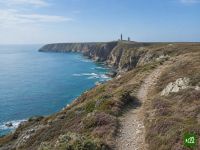
A coastal walk along the north shore of Brittany, following the old customs officers' path from Mont-Saint-Michel to the ferry port of Roscoff. It traces cliff tops, rocky headlands and long tidal beaches past Cap Fréhel, the bay of Saint-Brieuc and the pink granite of Ploumanac'h.
GR34 map
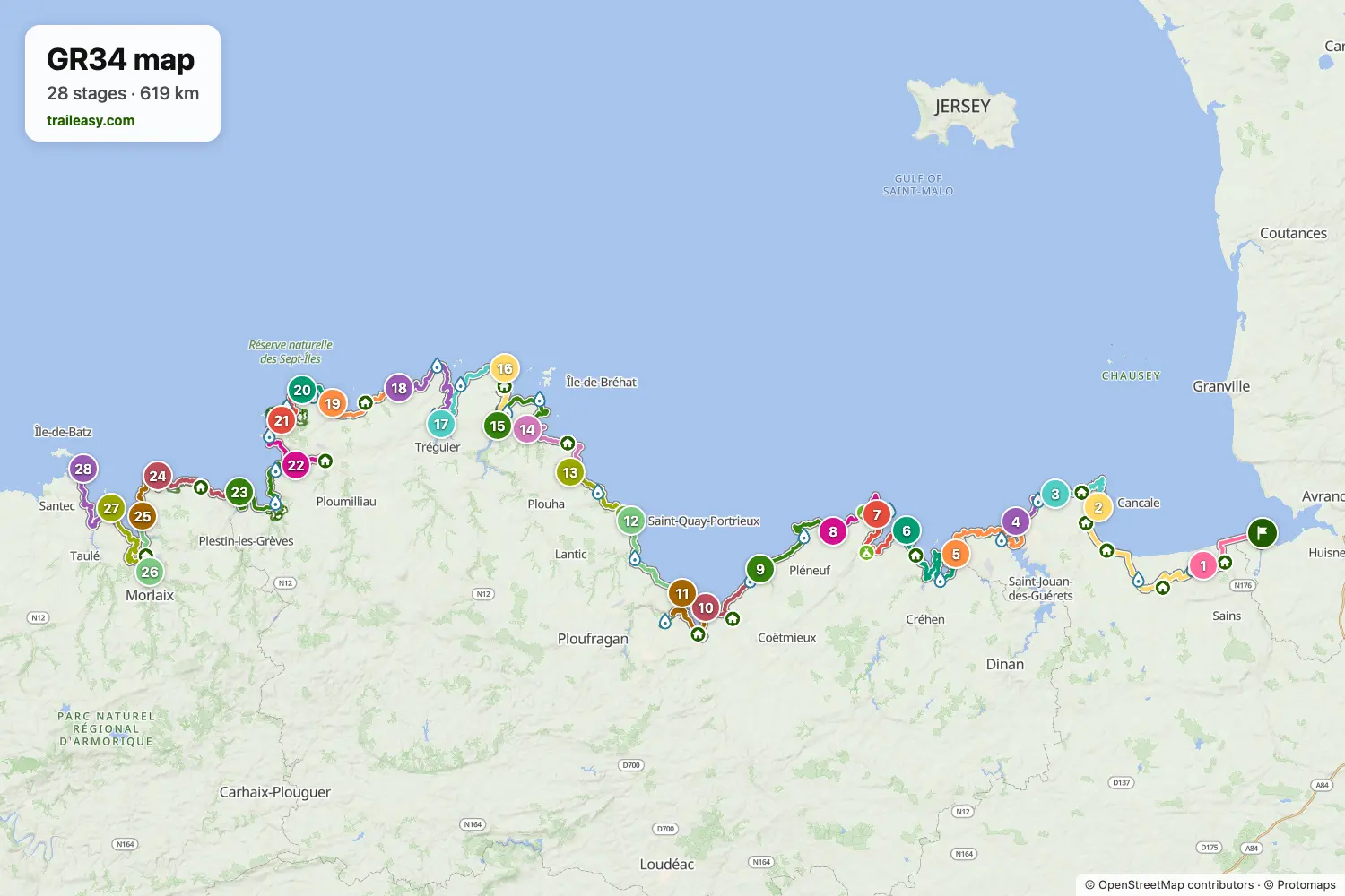
The interactive map shows the whole route, with accommodation, water and public transport along the way.
GR34 route planner
Build a day-by-day itinerary in the route planner, find accommodations along the route, and download the GPX file. Start from an example below or from scratch.
28-Day ItineraryShown below
The full walk along the old customs officers' path around the north coast of Brittany, starting beneath Mont-Saint-Michel and finishing at the ferry port of Roscoff. It follows the Emerald Coast past Cap Fréhel, rounds the bay of Saint-Brieuc and the estuaries of the Trieux and the Jaudy, then traces the pink granite headlands of Ploumanac'h and the wide sands of the Bay of Morlaix. The daily stages follow the classic guidebook split, ending each day in a coastal town or harbour with lodging.
GR34 stages
28 days, 640 km and 13,110 m of ascent. These stages follow the 28-Day Itinerary. Open it in the route planner to split or merge days and choose where you sleep.
- Stage 119.4 km↑ 151 m · ↓ 162 m ·
5–6h with stopsTo Saint-Broladre
Night at Au Bon Accueil - Stage 235.2 km↑ 314 m · ↓ 319 m ·
10–11h with stopsSaint-Broladre Cancale
Night at La Mère Champlain - Restaurant ET Hôtel - Stage 321.5 km↑ 742 m · ↓ 722 m ·
7–8h with stopsCancale La Guimorais
Night at Camping Chevrets - Stage 414.6 km↑ 169 m · ↓ 186 m ·
4–5h with stopsLa Guimorais Saint-Malo
Night at Hôtel France et Chateaubriand Saint-Malo - Stage 533.6 km↑ 662 m · ↓ 648 m ·
10–11h with stopsSaint-Malo Lancieux
Night at Hôtel des Bains - Stage 633.3 km↑ 533 m · ↓ 528 m ·
10–11h with stopsLancieux Saint-Cast-le-Guildo
Night at Hôtel Port-Jacquet - Stage 727.0 km↑ 823 m · ↓ 788 m ·
9–10h with stopsSaint-Cast-le-Guildo Cap Fréhel
Night at gîte d'étape Domaine de l'entre-deux - Stage 816.5 km↑ 248 m · ↓ 300 m ·
5–6h with stopsCap Fréhel Sables-d'Or-les-Pins
Night at Hôtel de Diane - Stage 925.3 km↑ 535 m · ↓ 537 m ·
8–9h with stopsSables-d'Or-les-Pins Pléneuf-Val-André
Night at Hôtel de la Mer - Stage 1022.3 km↑ 753 m · ↓ 719 m ·
7–8h with stopsPléneuf-Val-André Hillion
Night at Camping Bellevue Mer - Stage 1124.9 km↑ 422 m · ↓ 392 m ·
7–8h with stopsHillion Saint-Laurent-de-la-Mer
Night at Manoir du Roselier - Stage 1221.9 km↑ 720 m · ↓ 760 m ·
7–8h with stopsSaint-Laurent-de-la-Mer Saint-Quay-Portrieux
Night at Hôtel Ker Moor Saint-Quay Portrieux - Stage 1320.1 km↑ 686 m · ↓ 634 m ·
7–8h with stopsSaint-Quay-Portrieux Bréhec
Night at Camping Varquez - Stage 1421.3 km↑ 570 m · ↓ 645 m ·
7–8h with stopsBréhec Paimpol
Night at Hôtel Le Goëlo - Stage 1522.7 km↑ 514 m · ↓ 498 m ·
7–8h with stopsPaimpol Lézardrieux
Night at Le Littoral - Stage 1615.8 km↑ 295 m · ↓ 313 m ·
5–6h with stopsLézardrieux Le Québo
Night at Camping Domaine de Laneros - Stage 1725.9 km↑ 296 m · ↓ 298 m ·
7–8h with stopsLe Québo Tréguier
Night at Hôtel AM Aigue Marine - Stage 1829.9 km↑ 407 m · ↓ 406 m ·
9–10h with stopsTréguier Port Blanc
Night at Grand Hotel De Port Blanc - Stage 1920.1 km↑ 336 m · ↓ 286 m ·
6–7h with stopsPort Blanc Perros-Guirec
Night at L'Agapa Hôtel - Spa - Stage 2011.4 km↑ 145 m · ↓ 188 m ·
3–4h with stopsPerros-Guirec Trégastel
Night at Hôtel Bar Restaurant Pâtisserie Le Beau Séjour - Stage 2114.2 km↑ 151 m · ↓ 154 m ·
4–5h with stopsTrégastel Île Grande
Night at Camping Hope - Stage 2231.4 km↑ 705 m · ↓ 642 m ·
10–11h with stopsÎle Grande Le Yaudet
Night at Aux Arbres Chanteurs - Stage 2332.4 km↑ 652 m · ↓ 711 m ·
10–11h with stopsLe Yaudet Locquirec
Night at Grand Hotel Des Bains - Stage 2421.0 km↑ 823 m · ↓ 820 m ·
7–8h with stopsLocquirec Plougasnou
Night at Camping municipal de la mer - Stage 2515.0 km↑ 236 m · ↓ 242 m ·
4–5h with stopsPlougasnou Saint-Samson
Night at Camping Baie De Terenez - Stage 2615.2 km↑ 229 m · ↓ 226 m ·
4–5h with stopsSaint-Samson Morlaix
Night at Hôtel du Port - Stage 2726.1 km↑ 690 m · ↓ 670 m ·
8–9h with stopsMorlaix Carantec
Night at L'Hôtel de Carantec - Stage 2822.0 km↑ 303 m · ↓ 323 m ·
6–7h with stopsCarantec Roscoff
Best time to go
- Best time1 Apr – 30 Jun, 1 Sept – 30 Sept
- Good time1 Mar – 31 Mar, 1 Jul – 31 Aug, 1 Oct – 31 Oct
- Possible, with care1 Nov – 29 Feb
April to June and September are the best months, with gorse and thrift along the cliff tops and long days on the coast. July and August are warm and settled but busy, and coastal accommodation fills early in the resort towns. From November to February gales come in off the Atlantic and many seasonal campsites, island boats and small hotels close until Easter.
Frequently asked questions
How long does it take to walk the GR34?
Walking the northern coast from Mont-Saint-Michel to Roscoff takes around four weeks at a steady pace, broken into twenty-eight stages by the Cicerone guidebook. Treat the figures you find elsewhere with care, because most of them describe the entire GR34 around the whole Breton coast to Saint-Nazaire, which is more than three times as long and takes the best part of three months. Very few people walk that full circuit, and the northern coast is what most walkers mean when they talk about doing the GR34. Daily stages range from a short half day to a long full one, so you can compress the month or stretch it out with rest days in Saint-Malo, Paimpol or Perros-Guirec. Plenty of walkers take a week or two and cover one region at a time, coming back for the rest later. The Traileasy planner puts every overnight on a town you can see on the map, so the length of every day is visible before any schedule is fixed.
Which part of the GR34 is best to walk?
The northern coast between Mont-Saint-Michel and Roscoff is the stretch most walkers choose, and it is the section this route covers. It strings together the Côte d'Émeraude around Saint-Malo and Dinard, the cliffs of Cap Fréhel and Fort-la-Latte, the wide Baie de Saint-Brieuc, the fishing harbours around Paimpol, and the pink granite of Ploumanac'h, which draws close to a million visitors a year on its own. Both ends are practical places to begin and finish, since Saint-Malo and Roscoff are ferry ports while Saint-Brieuc and Morlaix sit on the Paris to Brest railway. The southern half is not inferior, and the Crozon peninsula and the Pointe du Raz match anything in the north, but it winds a long way inland around the deep estuaries and rias of Finistère and the Morbihan. If you only have a week, the Côte de Granit Rose between Perros-Guirec and Trébeurden and the run past Cap Fréhel are the two stretches to prioritise.
When is the best time to walk the GR34?
May, June and September. On a coast path this long the season shifts with where you are: the north coast around the Côtes d'Armor is windier and cooler, while the sheltered south around the Morbihan is comfortable weeks earlier in spring and weeks later in autumn. Pick the section to suit the month and the year opens up considerably. Rain comes through as showers driven on the wind rather than settling in for days, which is why good waterproofs beat a fixed forecast here. The winter constraint is not the path, which stays open, but the seasonal campsites, island boats and small hotels that shut until Easter.
How do the tides affect walking the GR34?
Tides decide which line you walk on several stages, because the trail crosses beaches, estuary mouths and tidal foreshore that vanish at high water. Brittany has some of the largest tidal ranges in Europe, and the bay at Mont-Saint-Michel is the most extreme example, so the sea retreats and returns across an enormous width of sand. French tide tables give each day a coefficient, and on a high coefficient the water reaches much further up the shore than it would at an ordinary high tide, which is what catches people out. The guidebook marks alternative lines for the affected sections, usually turning inland onto lanes for a short way before returning to the coast, and the crossing of the Lieue de Grève near Saint-Michel-en-Grève is the one to plan around properly, since its inland detour is several times longer. Check the day's tide table before you set out rather than at the water's edge, and never begin a foreshore crossing on a rising tide. Traileasy carries those high water alternatives as route variants you can switch on while building a stage, so the inland line is already in your itinerary instead of something to improvise.
How difficult is the GR34?
It is a moderate walk with no technical difficulty, but it is harder underfoot than an almost flat coastal profile suggests. There is no altitude to speak of, since the path rarely rises above the height of the cliff tops, yet it drops into and climbs out of every cove and river mouth, and those short repeated ascents add up to a serious total across a full day. The surface changes constantly between sand, bare granite, mud, boardwalk, cliff steps and village pavement, so feet and ankles take more punishment than the gradients imply. Waymarking is good, with the red and white flashes of the French GR network carried on posts, rocks and walls, and route finding is rarely a problem when the coast itself is the handrail. Exposure is the real hazard rather than terrain, because long stretches of cliff edge are unfenced and Atlantic wind and rain arrive with very little shelter. Anyone comfortable with consecutive long days on rough ground can manage it without mountain experience.
How do you get to the GR34 from the UK?
Brittany Ferries sails from southern England straight to two towns on this section, Saint-Malo and Roscoff, which makes the route unusually easy to reach without flying. Roscoff is the finish and Saint-Malo sits a few stages in, so you can arrive by sea at one end and leave by sea at the other. For the official start at Mont-Saint-Michel, the nearest station is Pontorson, reached by train from Rennes, which connects onward to Saint-Malo and Paris. Further along, Saint-Brieuc and Morlaix both sit on the Paris to Brest main line, so a section walk can start and finish at a station rather than an isolated trailhead. Local buses link the smaller coastal villages to those towns, though services thin out considerably on Sundays and outside the summer season.
Can you wild camp along the GR34?
Wild camping is not permitted along most of the GR34, since French law restricts camping on the seashore and many coastal communes ban it outright by local order. The protected coastal strip that keeps this shoreline undeveloped is the same rule that stops you pitching on it, and enforcement is real in the popular areas, particularly around Cap Fréhel, the Côte de Granit Rose and the approaches to Mont-Saint-Michel. Discreet bivouac, meaning arriving at dusk, putting up no structure and leaving at first light, is tolerated in some quieter spots set back from the path, but it is a tolerance rather than a right and it does not extend to the beaches or the cliff tops. In practice you do not need it, because campsites are dense along this coast and most towns of any size run an inexpensive municipal one that is used to walkers. Many of those campsites close outside the summer season, so check opening dates if you are walking in spring or autumn.