
Coronallacs
About Coronallacs
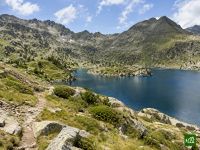
Coronallacs is Andorra's hut-to-hut circuit, a demanding high-mountain loop from Escaldes-Engordany that links the country's four staffed refuges. It climbs through the UNESCO-listed Madriu-Perafita-Claror valley, then crosses one high pass after another between lake-filled cirques on its way round the Principality.
Coronallacs map
The interactive map shows the whole route, with accommodation, water and public transport along the way.
Coronallacs route planner
Build a day-by-day itinerary in the route planner, find accommodations along the route, and download the GPX file. Start from an example below or from scratch.
5-Day ItineraryShown below
A five-day loop of Andorra's four staffed refuges on the official stages, starting and finishing in Escaldes-Engordany. The first day climbs the UNESCO-listed Madriu-Perafita-Claror valley to Refugi de l'Illa. The second crosses the Collada dels Pessons, the high point of the circuit, drops to the road at Bordes d'Envalira and climbs again to Refugi de Juclà. The third passes the Cabana Sorda and Coms de Jan huts on the way to Borda de Sorteny. The fourth, the hardest, goes down through El Serrat and Llorts in the Ordino valley and climbs towards Clot del Cavall to Refugi del Comapedrosa. The last day crosses Coll de la Botella and comes down through Sispony and Andorra la Vella to Escaldes.
Coronallacs stages
5 days, 94 km and 6,799 m of ascent. These stages follow the 5-Day Itinerary. Open it in the route planner to split or merge days and choose where you sleep.
- Stage 113.1 km↑ 1,480 m · ↓ 34 m ·
5–6h with stopsEscaldes-Engordany Refugi de l'Illa
Night at Refugi de l'Illa - Stage 220.3 km↑ 1,355 m · ↓ 1,530 m ·
8–9h with stopsOver the Collada dels Pessons Refugi de Juclà
Night at Refugi de Juclar - Stage 317.1 km↑ 1,462 m · ↓ 1,804 m ·
8–9h with stopsRefugi de Juclà Refugi Borda de Sorteny
Night at Refugi Borda de Sorteny - Stage 421.9 km↑ 1,892 m · ↓ 1,597 m ·
10–11h with stopsThrough the Ordino valley Refugi del Comapedrosa
Night at Refugi del Comapedrosa | 2.260 m - Stage 521.9 km↑ 610 m · ↓ 1,834 m ·
8–9h with stopsBack Escaldes-Engordany
Best time to go
- Best time1 Jul – 30 Sept
- Good time16 Jun – 30 Jun, 1 Oct – 12 Oct
- Possible, with care1 Jun – 15 Jun
July to September is the time to go. The Juclà, Sorteny and Comapedrosa refuges open on 1 June and l'Illa on the first weekend of June, but snow can lie on the high cols all month, most of all in the first half, so check conditions with the refuge guardians. Thunderstorms are common on summer afternoons, so start early; August is the busiest month. The season ends when Comapedrosa closes on 12 October, and in October the longest stages take up nearly all the daylight.
Frequently asked questions
How many days do you need for the Coronallacs, and can you split the long stages?
Five days on the official plan, with one night in each of Andorra's four guarded refuges. That plan is tight. On Visit Andorra's own timings, four of the five stages take between nine and eleven hours of walking, so many people stretch the circuit to six or seven days. Visit Andorra itself suggests an extra night at L'Illa or at Sorteny. The long second stage can be broken at the free Pla de les Pedres refuge, or with a detour to the hotel at Grau Roig. On the last day you can take the bus from Sispony instead of walking the final stretch down through Andorra la Vella. Some fast walkers link stages and finish in four days, which means very long days indeed. The Traileasy planner recalculates the length and climb of every day as you add or move a night, so you can see what a stop at Pla de les Pedres does to that second stage before you fix any dates.
How hard is the Coronallacs, and is it suitable for a first hut-to-hut trek?
It is hard because of its length, not because of any technical step. The two official sources do not agree on a grade: the Coronallacs website calls it medium to medium-high depending on the section, while Visit Andorra rates it very difficult. The day lengths side with Visit Andorra. In the organisers' own comparison of eighteen Pyrenean hut circuits, it comes second for both distance per day and climb per day, ahead of Carros de Foc. The high point is the Collada dels Pessons, at 2,810 m, on the second stage. The hardest day is the fourth, from Sorteny to Comapedrosa, with a steep climb towards Clot del Cavall that ends on loose scree. Long sections have no shade at all. As a first hut-to-hut trek it suits fit walkers who already cope well with long mountain days. If you have never walked nine or ten hours on rough ground, add a night or two rather than taking the five-day plan as it stands.
Where does the Coronallacs start, and how do you get to Escaldes-Engordany?
It starts and finishes at the tourist office in Plaça Santa Anna, in the centre of Escaldes-Engordany. That is where you show your booking voucher and collect the map and the route passport. If you arrive outside opening hours, the booking conditions let you collect the passport at Refugi de l'Illa instead. Andorra has no airport and no railway, so most walkers arrive by coach. Direct coaches run from Barcelona airport and Sants station, and from Toulouse airport, to the bus station in Andorra la Vella. The two towns run into each other, so the tourist office is a short walk away. Local buses stop in Plaça Santa Anna itself. If you drive, the official booking lets you add a parking pass, though a space is not guaranteed in August. The five official stages run anticlockwise, up the Madriu valley to L'Illa on the first day and back through Sispony on the last.
How do you book the Coronallacs refuges, and do you need the official package?
There are two ways, and the route passport comes with the official one. The Coronallacs website books all four refuges as a package with half board. Its conditions are strict: you pay the full amount online, each night is tied to one date at one refuge, nothing can be changed once confirmed, and the package is not refunded if you cancel. According to the official site, the passport, which you have stamped at each refuge and exchange at the tourist office for a certificate and a buff, is only for people who booked through it. If the certificate matters to you, book that way. The alternative is to book each refuge yourself by phone, email or its own booking page, which leaves you free to add nights or change plans. Each refuge sets its own prices. Book well ahead for July, August and Spanish public holidays. Carry cash too, because Juclà does not take cards and the official FAQ warns that connections in the mountains are unreliable.
What happens if the weather turns on the Coronallacs, and where can you leave the route?
Most stages have one place where the route comes down to a road with a bus. That is where the weather decision belongs. On the second stage it is Bordes d'Envalira, on the main road between Pas de la Casa and Soldeu. After that the route climbs back into the mountains and there is no road until Juclà. On the fourth stage it is El Serrat and Llorts in the Ordino valley, just before the long climb towards Clot del Cavall. The last day crosses the road at Coll de la Botella and passes a bus stop at Sispony. Once out of Escaldes the first stage touches no road, and neither does the third, so check the forecast the evening before. The organisers point to meteo.ad, the national weather service, which also posts warnings, and advise an early start because conditions change fast up high. Juclà and Sorteny both sit at the head of valleys with a road below, though some of those valley buses only run in high summer. A clear day has its own problem: long stretches have no shade, so carry more water than you think you will need.
Is the Coronallacs waymarked, and will your phone work along the route?
Yes, it is waymarked all the way round. For most of its length it shares the yellow and red marks of the GRP, Andorra's own round-the-country trail, with some white and red GR marks, and the Coronallacs adds black and sky-blue signs of its own. Because the two share so much ground, some apps and guides call it the "GRP Coronallacs". The GRP is a separate circuit, though, and where the two part company you follow the Coronallacs signs. The organisers do not make the GPX track compulsory, but they strongly recommend carrying it. Phone coverage is reasonable on much of the route, and 112 reaches the emergency services. Mobile data is another matter. Andorra is not in the EU, so EU roaming rules do not apply and many plans charge heavily there, which makes it worth checking yours before you go. The Traileasy app holds the Coronallacs you planned on an offline map, so following it from the Madriu valley round to Comapedrosa needs no mobile data, and the route you built can go to a GPS watch as a GPX export.
Can you wild camp or sleep in the free refuges on the Coronallacs?
Yes to the free refuges. Camping depends on the parish and the park you are in. Andorra keeps a network of 22 unguarded refuges open all year, and nine of them lie on or close to the Coronallacs. Fontverd and Riu dels Orris are in the Madriu valley, Pla de les Pedres and Siscaró on the second stage, Cabana Sorda and Coms de Jan on the third, and Angonella, Les Fonts and Pla de l'Estany on the fourth. They are simple huts with bunks, a stove or fireplace and water nearby, but no warden and no meals, and they are only cleaned in summer. L'Illa also keeps an unguarded room open all year. For tents there is no single national rule. The official Coronallacs site says bivouacking is possible above 2,000 metres and only at night. In the Madriu valley camping needs the parish council's permission, which in Escaldes-Engordany only applies to more than three tents staying more than two nights. The Comapedrosa park requires authorisation for camps of more than three tents and bans fires, and it approved a new management plan in 2026, so check its current rules. In the Sorteny park and on the Canillo and Encamp stretches, ask the park or the parish before you pitch. Nights outside the four guarded refuges earn no passport stamp, and the certificate needs all four.