
Tour du Mont Blanc
Informazioni su Tour du Mont Blanc
Questo iconico anello di 170 km circonda la vetta più alta dell'Europa occidentale, attraversando prati alpini, valli glaciali e passi di montagna in tre paesi. Il percorso offre viste spettacolari sul massiccio glaciale del Monte Bianco e collega affascinanti villaggi di montagna.
Tour du Mont Blanc: la mappa
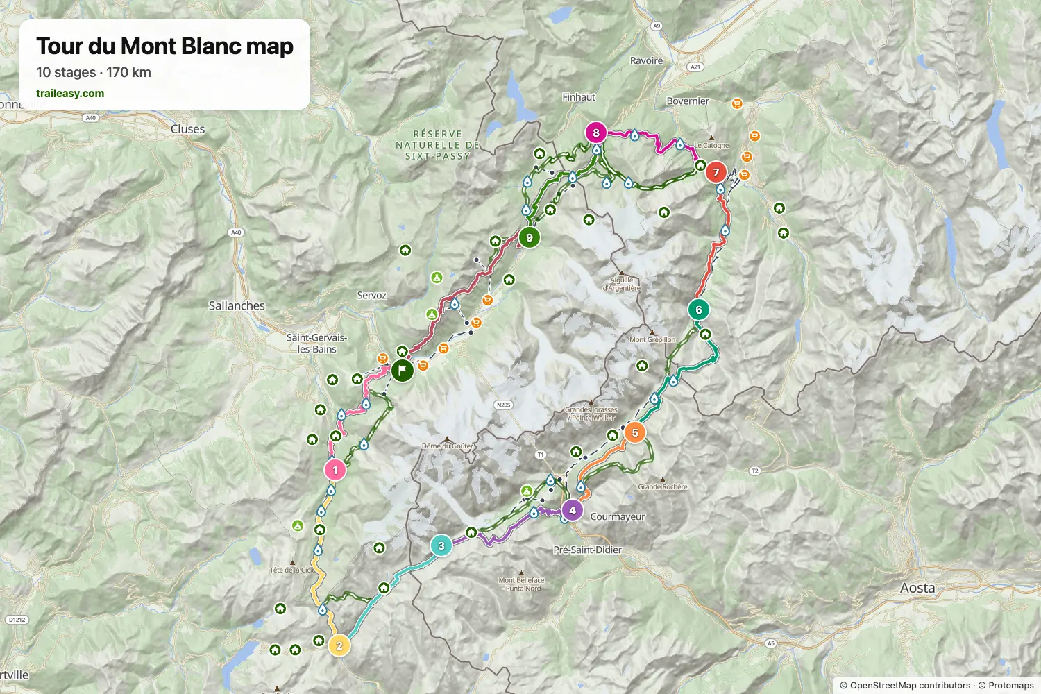
La mappa interattiva mostra tutto il percorso, con alloggi, punti acqua e trasporti pubblici lungo il cammino.
Pianificatore di percorso: Tour du Mont Blanc
Crea un itinerario giorno per giorno nel pianificatore, trova alloggi lungo il percorso e scarica il file GPX. Parti da un esempio qui sotto o da zero.
10-Day ItineraryMostrato sotto
A relaxed 10-day counter-clockwise Tour du Mont Blanc circuit through France, Italy, and Switzerland. This classic route splits the Col de la Seigne crossing with a memorable night at Rifugio Elisabetta, offering stunning views of the Aiguille des Glaciers and Mont Blanc massif.
8-Day Itinerary
The Tour du Mont Blanc counter-clockwise from Les Houches in eight days, for walkers who are happy with long stages. The first day carries on past Les Contamines to the Refuge de Nant Borrant, which shortens the crossing of the Col du Bonhomme to the Refuge des Mottets the next day. From there the route goes over the Col de la Seigne into Italy and down to Courmayeur, follows the balcony above the Italian Val Ferret to Rifugio Elena, and crosses the Grand Col Ferret to Champex-Lac in one stage. The last three days take the Bovine path to Trient, the Col de Balme to the Refuge de La Flégère, and the Brévent back to Les Houches.
Tour du Mont Blanc in 9 Days
The Tour du Mont Blanc counter-clockwise through France, Italy and Switzerland in nine days, with the long stages split at huts along the way: Rifugio Elisabetta below Col de la Seigne, Rifugio Bertone above Courmayeur and Alpage de la Peule past Grand Col Ferret. The last two days cross Col de Balme to the Refuge de La Flégère, facing the Mont Blanc massif, and finish over the Brévent at Les Houches.
9-Day Itinerary Camping
This classic counter-clockwise Tour du Mont Blanc circuit covers 182 km over 9 days, starting and finishing in Les Houches with a campsite every night. From Les Contamines it climbs the Col du Bonhomme to Les Chapieux, crosses the Col de la Seigne into Italy's Val Veny beneath the Mont Blanc massif, follows the high balcony past the Grandes Jorasses to Val Ferret, then traverses the Grand Col Ferret into Switzerland via La Fouly, Champex-Lac and Trient before the Col de Balme and the Grand Balcon Sud under Le Brevent bring it back to Les Houches. It is a tent hiker's campsite-to-campsite split, with three big pass days (Col de la Seigne, Grand Col Ferret and the final Flegere-Brevent traverse) offset by shorter valley stages in between.
Classic 11-Day Tour du Mont Blanc
The complete counter-clockwise circuit around Mont Blanc, the highest peak in the Alps. This 170km trek passes through France, Italy, and Switzerland, crossing stunning alpine passes with views of glaciers, dramatic peaks, and charming mountain villages. Starting from Chamonix, this 11-day itinerary follows the most popular route with comfortable accommodation in hotels, auberges, and mountain refuges.
Cosa dicono gli escursionisti verificati
Tour du Mont Blanc: le tappe
10 giorni, 169 km e 10.466 m di dislivello positivo. Queste tappe seguono l'itinerario «10-Day Itinerary». Aprilo nel pianificatore per dividere o unire le giornate e scegliere dove dormire.
- Tappa 117,3 km↑ 1108 m · ↓ 933 m ·
7-8h con sosteLes Houches Les Contamines-Montjoie
Notte a Chalet Hotel Gai Soleil - Tappa 219,0 km↑ 1381 m · ↓ 1010 m ·
8-9h con sosteLes Contamines-Montjoie Les Chapieux
Notte a Auberge de la Nova - Tappa 313,9 km↑ 1039 m · ↓ 404 m ·
5-6h con sosteLes Chapieux Rifugio Elisabetta
Notte a Rifugio Elisabetta - Tappa 416,2 km↑ 549 m · ↓ 1528 m ·
6-7h con sosteRifugio Elisabetta Courmayeur
Notte a Hotel Bouton d'Or - Courmayeur - Tappa 512,0 km↑ 1098 m · ↓ 277 m ·
5-6h con sosteCourmayeur Rifugio Bonatti
Notte a Rifugio Walter Bonatti - Tappa 619,5 km↑ 958 m · ↓ 1384 m ·
7-8h con sosteRifugio Bonatti La Fouly
Notte a Hotel Edelweiss La Fouly - Tappa 714,9 km↑ 539 m · ↓ 667 m ·
5-6h con sosteLa Fouly Champex-Lac
Notte a Hôtel spa Au Club Alpin - Tappa 816,2 km↑ 839 m · ↓ 1034 m ·
6-7h con sosteChampex-Lac Trient
Notte a The Auberge du Mont Blanc - Tappa 915,2 km↑ 1151 m · ↓ 1170 m ·
6-7h con sosteTrient Argentière
Notte a Hôtel de La Couronne - Tappa 1024,8 km↑ 1804 m · ↓ 2055 m ·
11-12h con sosteArgentière Les Houches
Quando andare
- Periodo migliore1 lug – 15 set
- Buon periodo16 giu – 30 giu
- Possibile, con attenzione16 set – 15 ott
I rifugi aprono a metà giugno e chiudono a metà settembre. Sui colli alti la neve resta fino ai primi di luglio, quindi conviene consultare il bollettino delle condizioni e sentire i rifugi prima di partire presto. Agosto è il mese più affollato e i posti si esauriscono con mesi di anticipo. Da metà settembre restano aperti solo gli alberghi di fondovalle e sui colli può nevicare.