
South West Coast Path
Informazioni su South West Coast Path
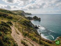
Uno dei sentieri nazionali più lunghi d'Inghilterra, che costeggia il litorale da Minehead nel Somerset attorno alle penisole del Devon, della Cornovaglia e del Dorset per concludersi a Poole Harbour. Il percorso si snoda tra spettacolari scogliere marine, calette appartate, villaggi di pescatori, spiagge sabbiose e la Costa Giurassica, con salite e discese incessanti che rivaleggiano con molti trekking di montagna.
South West Coast Path: la mappa
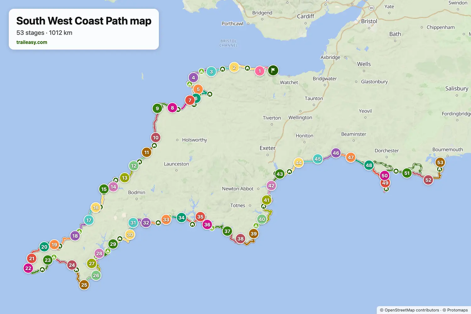
La mappa interattiva mostra tutto il percorso, con alloggi, punti acqua e trasporti pubblici lungo il cammino.
Pianificatore di percorso: South West Coast Path
Crea un itinerario giorno per giorno nel pianificatore, trova alloggi lungo il percorso e scarica il file GPX. Parti da un esempio qui sotto o da zero.
53 Day Full ItineraryMostrato sotto
A end-to-end traverse of the South West Coast Path National Trail across 53 daily stages, from Minehead in Somerset to South Haven Point on Studland Heath in Dorset. The first half threads the Exmoor cliffs and North Cornwall's surf coast through Lynmouth, Hartland Quay, Tintagel and Padstow, then loops Land's End via Sennen Cove and Penzance. The second half traces Cornwall's south coast through the Lizard, Falmouth and the Roseland to Fowey and Looe, crosses Plymouth Sound, then climbs the South Devon cliffs to Salcombe and Dartmouth before easing along the Riviera to Exmouth and onto the Jurassic Coast — Lyme Regis, Weymouth, Lulworth Cove and the Purbeck headlands before the final cliffs above Old Harry Rocks. Day splits follow the National Trail's recommended pacing, with longer routed distances on stages where the trail's tidal-river ferries are bypassed.
St Ives to Plymouth (Section 2)
The Cornish corner of the South West Coast Path, 16 days from St Ives to Plymouth. The opening stretch crosses the granite Penwith peninsula past Iron Age field walls and abandoned engine houses to Land's End, then turns east. The south coast feels different from the north — lower cliffs, sandy coves, and a sheltered, near-sub-tropical microclimate around Penzance and the Helford river. The Lizard peninsula reaches mainland Britain's most southerly point over its distinctive serpentine cliffs. From Falmouth onwards progress is repeatedly broken by tidal estuaries crossed by small passenger ferries. The section ends across the Tamar into Plymouth.
Plymouth to Studland (Section 3)
South Devon and the Jurassic Coast, 18 days from Plymouth to the trail's end at Studland. The South Devon cliffs from Plymouth past Salcombe and Start Point are steep and remote again after the gentler south Cornish coast, broken by the long shingle line of Slapton Sands. East of Exmouth the trail follows the Jurassic Coast — a World Heritage Site where the cliffs cycle through Triassic red sandstone with fossil beaches at Charmouth and Lyme Regis. The final week features the long Chesil Beach shingle barrier, the limestone bulk of the Isle of Portland, the cove and arch at Lulworth and Durdle Door, and the chalk stacks of Old Harry Rocks before the trail terminus at South Haven Point on Studland Heath, opposite Sandbanks across the mouth of Poole Harbour.
Minehead to St Ives (Section 1)
The first and most strenuous stretch of the South West Coast Path, 19 days from Minehead to St Ives. The route climbs straight onto the Exmoor coast and crosses Great Hangman, the highest sea cliff on mainland England. After easier ground around the Taw and Torridge estuaries and the long sands at Woolacombe, the Hartland coast delivers the toughest walking on the entire trail: a relentless in-and-out profile through steep wooded combes, with few road crossings and full Atlantic exposure. South of Bude the path follows North Cornwall's slate cliffs and surf beaches through old tin and copper mining country before finishing at St Ives.
South West Coast Path: le tappe
53 giorni, 1062 km e 33.887 m di dislivello positivo. Queste tappe seguono l'itinerario «53 Day Full Itinerary». Aprilo nel pianificatore per dividere o unire le giornate e scegliere dove dormire.
- Tappa 114,6 km↑ 497 m · ↓ 468 m ·
5-6h con sosteVerso Porlock
Notte a Myrtle Cottage - Tappa 221,9 km↑ 933 m · ↓ 961 m ·
8-9h con sostePorlock Lynmouth
Notte a The Rising Sun - Tappa 322,2 km↑ 1015 m · ↓ 994 m ·
8-9h con sosteLynmouth Combe Martin
Notte a John Fowler Holidays - Combe Martin Beach - Tappa 422,5 km↑ 992 m · ↓ 1001 m ·
8-9h con sosteCombe Martin Woolacombe
Notte a Woolacombe Bay Hotel - Tappa 524,3 km↑ 295 m · ↓ 305 m ·
7-8h con sosteWoolacombe Braunton
Notte a Stockwell Lodge - Tappa 619,0 km↑ 30 m · ↓ 29 m ·
5-6h con sosteBraunton Instow
Notte a Commodore Instow - Tappa 717,8 km↑ 125 m · ↓ 124 m ·
5-6h con sosteInstow Westward Ho!
Notte a The Waterfront Inn - Tappa 819,0 km↑ 742 m · ↓ 745 m ·
6-7h con sosteWestward Ho! Clovelly
Notte a The Red Lion Hotel - Tappa 916,7 km↑ 749 m · ↓ 741 m ·
6-7h con sosteClovelly Hartland Quay
Notte a Hartland Quay Hotel - Tappa 1024,9 km↑ 1103 m · ↓ 1115 m ·
9-10h con sosteHartland Quay Bude
Notte a The Brendon Arms - Tappa 1116,7 km↑ 709 m · ↓ 702 m ·
6-7h con sosteBude Crackington Haven
Notte a The Coombe Barton Inn - Tappa 1218,3 km↑ 990 m · ↓ 914 m ·
7-8h con sosteCrackington Haven Tintagel
Notte a King Arthur's Arms Hotel - Tappa 1316,3 km↑ 818 m · ↓ 893 m ·
6-7h con sosteTintagel Port Isaac
Notte a The Old School Hotel - Tappa 1420,8 km↑ 794 m · ↓ 806 m ·
7-8h con sostePort Isaac Padstow
Notte a Old Custom House, Padstow - Tappa 1518,2 km↑ 351 m · ↓ 341 m ·
5-6h con sostePadstow Porthcothan
Notte a YHA Treyarnon Bay - Tappa 1623,3 km↑ 747 m · ↓ 736 m ·
8-9h con sostePorthcothan Newquay
Notte a The Headland - Tappa 1721,1 km↑ 527 m · ↓ 505 m ·
7-8h con sosteNewquay Perranporth
Notte a YHA Perranporth - Tappa 1819,8 km↑ 668 m · ↓ 637 m ·
7-8h con sostePerranporth Portreath
Notte a Gwel an Mor Resort - Tappa 1929,2 km↑ 852 m · ↓ 839 m ·
10-11h con sostePortreath St Ives
Notte a Tregenna Castle Resort - Tappa 2012,8 km↑ 477 m · ↓ 460 m ·
4-5h con sosteSt Ives Zennor
Notte a White House Zennor - Tappa 2123,1 km↑ 834 m · ↓ 818 m ·
8-9h con sosteZennor St Just
Notte a The Old Post House B&B - Tappa 229,9 km↑ 295 m · ↓ 348 m ·
3-4h con sosteSt Just Sennen Cove
Notte a The Land's End Hotel - Tappa 2325,3 km↑ 887 m · ↓ 950 m ·
9-10h con sosteSennen Cove Penzance
Notte a Queens Hotel - Tappa 2423,6 km↑ 597 m · ↓ 597 m ·
7-8h con sostePenzance Porthleven
Notte a Harbour Inn, Porthleven - Tappa 2524,5 km↑ 782 m · ↓ 714 m ·
8-9h con sostePorthleven The Lizard
Notte a The Top House Inn - Tappa 2616,4 km↑ 528 m · ↓ 592 m ·
5-6h con sosteThe Lizard Coverack
Notte a Paris Hotel - Tappa 2721,3 km↑ 670 m · ↓ 671 m ·
7-8h con sosteCoverack Helford
Notte a Shipwrights Arms - Tappa 2816,6 km↑ 400 m · ↓ 404 m ·
5-6h con sosteHelford Falmouth
Notte a Chain Locker, Falmouth - Tappa 2921,9 km↑ 455 m · ↓ 436 m ·
7-8h con sosteFalmouth Portscatho
Notte a The Nare Hotel - Tappa 3024,9 km↑ 1011 m · ↓ 1031 m ·
9-10h con sostePortscatho Mevagissey
Notte a The Rising Sun Inn - Tappa 3112,8 km↑ 655 m · ↓ 651 m ·
5-6h con sosteMevagissey Charlestown
Notte a Pier House Hotel, Charlestown - Tappa 3216,4 km↑ 520 m · ↓ 514 m ·
5-6h con sosteCharlestown Fowey
Notte a Tides Reach - Tappa 3319,7 km↑ 789 m · ↓ 774 m ·
7-8h con sosteFowey Looe
Notte a The Gulls - Tappa 3413,3 km↑ 531 m · ↓ 540 m ·
4-5h con sosteLooe Portwrinkle
Notte a The Nooke - Tappa 3526,8 km↑ 611 m · ↓ 615 m ·
8-9h con sostePortwrinkle Plymouth
Notte a Crowne Plaza Plymouth by IHG - Tappa 3620,2 km↑ 452 m · ↓ 413 m ·
6-7h con sostePlymouth Wembury
Notte a Sea Breeze Wembury Beach - Three-Bedroom House - Tappa 3725,1 km↑ 766 m · ↓ 803 m ·
8-9h con sosteWembury Bigbury-on-Sea
Notte a Coastguards - Four-Bedroom House - Tappa 3821,8 km↑ 776 m · ↓ 744 m ·
7-8h con sosteBigbury-on-Sea Salcombe
Notte a The Fo'c'sle & Pengwern - Tappa 3922,0 km↑ 726 m · ↓ 779 m ·
7-8h con sosteSalcombe Torcross
Notte a Reeds - Tappa 4015,9 km↑ 495 m · ↓ 497 m ·
5-6h con sosteTorcross Dartmouth
Notte a The Royal Castle - Tappa 4131,0 km↑ 1208 m · ↓ 1199 m ·
11-12h con sosteDartmouth Torquay
Notte a Premier Inn Torquay Seafront hotel - Tappa 4220,1 km↑ 942 m · ↓ 946 m ·
7-8h con sosteTorquay Teignmouth
Notte a The Thornhill - Tappa 4315,5 km↑ 143 m · ↓ 143 m ·
4-5h con sosteTeignmouth Exmouth
Notte a Premier Inn Exmouth Seafront hotel - Tappa 4420,6 km↑ 556 m · ↓ 545 m ·
7-8h con sosteExmouth Sidmouth
Notte a Woodlands Hotel Sidmouth - Tappa 4517,2 km↑ 698 m · ↓ 707 m ·
6-7h con sosteSidmouth Seaton
Notte a Mariners Hotel - Tappa 4617,7 km↑ 622 m · ↓ 612 m ·
6-7h con sosteSeaton Charmouth
Notte a Hensleigh House - Tappa 4711,5 km↑ 597 m · ↓ 609 m ·
4-5h con sosteCharmouth West Bay
Notte a 2 Bed in West Bay (oc-d31037) - Tappa 4815,8 km↑ 176 m · ↓ 138 m ·
4-5h con sosteWest Bay Abbotsbury
Notte a The Ilchester Arms Abbotsbury - Tappa 4921,2 km↑ 263 m · ↓ 303 m ·
6-7h con sosteAbbotsbury Fortuneswell
Notte a The Bunker - Tappa 5023,5 km↑ 441 m · ↓ 433 m ·
7-8h con sosteFortuneswell Weymouth
Notte a Fishermans Cottage - Tappa 5119,5 km↑ 675 m · ↓ 669 m ·
6-7h con sosteWeymouth Lulworth Cove
Notte a Lulworth Holiday Cottage - Tappa 5222,7 km↑ 939 m · ↓ 851 m ·
8-9h con sosteLulworth Cove Worth Matravers
Notte a 4 Bed in Worth Matravers oc-ic036 - Tappa 5325,1 km↑ 433 m · ↓ 541 m ·
8-9h con sosteWorth Matravers Studland
Quando andare
- Periodo migliore1 apr – 30 giu, 1 set – 30 set
- Buon periodo1 mar – 31 mar, 1 lug – 31 ago, 1 ott – 31 ott
- Possibile, con attenzione1 nov – 29 feb
Da aprile a giugno e a settembre sono i mesi migliori sulle scogliere, con i fiori selvatici, le giornate lunghe e tutti i traghetti degli estuari in funzione. Luglio e agosto sono caldi sui tratti esposti e le località della Cornovaglia sono al massimo. Da novembre a febbraio diversi traghetti si fermano per l'inverno, e ognuno mancato comporta una lunga deviazione nell'entroterra, oltre alle burrasche e alle giornate corte.