
Lechweg
Informazioni su Lechweg
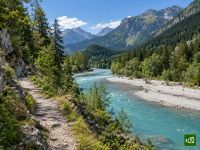
Il Lechweg accompagna il Lech dalla sorgente, vicino al Formarinsee sopra Lech am Arlberg, fino alla cascata del Lechfall a Füssen, scendendo lungo tutta la valle tirolese del Lechtal. Il Lech è uno degli ultimi fiumi selvaggi d'Europa, con acque turchesi che si dividono in tanti rami su ampi greti di ghiaia. Il sentiero attraversa villaggi walser, passa accanto alle facciate dipinte di Holzgau e, poco prima dell'arrivo, costeggia l'Alpsee ai piedi dei castelli reali di Neuschwanstein e Hohenschwangau.
Lechweg: la mappa
La mappa interattiva mostra tutto il percorso, con alloggi, punti acqua e trasporti pubblici lungo il cammino.
Pianificatore di percorso: Lechweg
Crea un itinerario giorno per giorno nel pianificatore, trova alloggi lungo il percorso e scarica il file GPX. Parti da un esempio qui sotto o da zero.
8-Day ItineraryMostrato sotto
The Lechweg in the operator's relaxed eight-stage plan, from the Freiburger Hütte above the Formarinsee, near the source of the Lech, down to the Lechfall in Füssen. The first day drops from the high pastures to Lech, the second climbs above the village to the Grenztobel and on up to the Walser village of Warth, and the third follows the panorama path past Lechleiten and down into the Tyrolean Lechtal to Steeg. From there the walk follows the Lech past the painted houses of Holzgau and the Simms waterfall to Bach, beside the river past Elbigenalp and Häselgehr to Elmen, and along the wide gravel beds of one of the last wild rivers in the Alps through Stanzach to Weißenbach. The seventh day passes Höfen and Wängle to Pflach, just outside Reutte, and the last crosses into Bavaria, skirting the Alpsee below the royal castles and climbing the Kalvarienberg before finishing at the Lechfall.
Lechweg: le tappe
8 giorni, 130 km e 2929 m di dislivello positivo. Queste tappe seguono l'itinerario «8-Day Itinerary». Aprilo nel pianificatore per dividere o unire le giornate e scegliere dove dormire.
- Tappa 115,9 km↑ 194 m · ↓ 672 m ·
5-6h con sosteVerso Lech
Notte a Hotel Arlberg Lech - Tappa 211,6 km↑ 465 m · ↓ 398 m ·
4-5h con sosteLech Warth
Notte a Wellnesshotel Warther Hof - Tappa 315,0 km↑ 298 m · ↓ 689 m ·
5-6h con sosteWarth Steeg
Notte a Lechquell Hotel Post - Tappa 415,6 km↑ 531 m · ↓ 591 m ·
5-6h con sosteSteeg Bach
Notte a Hotel Post - Tappa 516,5 km↑ 205 m · ↓ 291 m ·
5-6h con sosteBach Elmen
Notte a Gasthof Kaiserkrone - Tappa 621,0 km↑ 332 m · ↓ 419 m ·
6-7h con sosteElmen Weißenbach am Lech
Notte a Hotel-Gasthof Goldenes Lamm - Tappa 718,8 km↑ 395 m · ↓ 440 m ·
6-7h con sosteWeißenbach am Lech Pflach
Notte a Gasthof Alpenblick - Tappa 815,7 km↑ 509 m · ↓ 545 m ·
5-6h con sostePflach Füssen
Quando andare
- Periodo migliore1 lug – 30 set
- Buon periodo16 giu – 30 giu
- Possibile, con attenzione16 mag – 15 giu, 1 ott – 15 ott
Il percorso completo apre nella seconda metà di giugno, quando si è sciolta l'ultima neve sul tratto alto tra il Formarinsee e Warth, e resta percorribile fino a metà ottobre. Il periodo migliore va da luglio a settembre, in piena stagione estiva a Lech, con l'autobus escursionistico che sale al Formarinsee dal mattino alla sera. Da metà maggio si può fare un percorso ridotto che parte più in basso, da Steeg o da Warth. Da inizio ottobre a Lech ci sono meno alloggi aperti e l'autobus per il Formarinsee sale solo poche volte al giorno.