
John Muir Way
Informazioni su John Muir Way
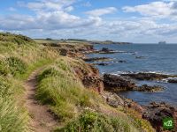
Il John Muir Way attraversa la Scozia da costa a costa, da Helensburgh, sul Firth of Clyde, fino a Dunbar, sul Mare del Nord, città natale del naturalista John Muir. Sale sulle brughiere che dominano il Loch Lomond, segue i vecchi canali lungo il Vallo di Antonino fino alla Falkirk Wheel, passa ai piedi dei ponti sul Forth, attraversa Edimburgo da parte a parte e si conclude tra le spiagge e le scogliere dell'East Lothian.
John Muir Way: la mappa
La mappa interattiva mostra tutto il percorso, con alloggi, punti acqua e trasporti pubblici lungo il cammino.
Pianificatore di percorso: John Muir Way
Crea un itinerario giorno per giorno nel pianificatore, trova alloggi lungo il percorso e scarica il file GPX. Parti da un esempio qui sotto o da zero.
10-Day ItineraryMostrato sotto
The John Muir Way walked coast to coast in ten days on its ten official sections, from the start plinth on Helensburgh's waterfront to John Muir's Birthplace in Dunbar, with a few overnights shifted a little along the trail so that no day is far harder than the rest. The first day climbs over Gouk Hill for the first views of Loch Lomond, drops to Balloch and carries on through Balloch Castle Country Park to stop just beyond the town. That takes some of the weight off the second day, the crossing of the Kilpatrick Hills to Strathblane, which is the highest and most remote ground of the whole route and still the longest day. From there the walking eases onto the Strathkelvin Railway Path and the Forth and Clyde Canal, over the Roman fort on Bar Hill to Auchinstarry Marina, then along the Antonine Wall over Croy Hill and past Rough Castle to the Falkirk Wheel. Beyond Falkirk the Way passes Callendar House, follows the Union Canal and the River Avon to Linlithgow Bridge and climbs Fishers' Brae above Linlithgow, so the next morning starts in Kinneil Estate and Bo'ness before the Forth shore leads past Blackness Castle and Hopetoun to the three bridges at South Queensferry. Edinburgh comes by Cramond, Corstorphine Hill, the Water of Leith and the Union Canal. The last three days run out along the East Lothian coast through Musselburgh to Port Seton, by Aberlady, Gullane and Dirleton to North Berwick, then inland by East Linton and the River Tyne and back to the sea at John Muir Country Park for the finish.
John Muir Way: le tappe
10 giorni, 216 km e 2360 m di dislivello positivo. Queste tappe seguono l'itinerario «10-Day Itinerary». Aprilo nel pianificatore per dividere o unire le giornate e scegliere dove dormire.
- Tappa 118,4 km↑ 454 m · ↓ 386 m ·
6-7h con sosteVerso Balloch
Notte a Westertonhill Holiday Lodges - Tappa 226,2 km↑ 490 m · ↓ 486 m ·
8-9h con sosteBalloch Strathblane
Notte a Kirkhouse Inn - Tappa 321,6 km↑ 163 m · ↓ 191 m ·
6-7h con sosteStrathblane Auchinstarry
Notte a The Boathouse Hotel Bar & Restaurant - Tappa 419,2 km↑ 258 m · ↓ 203 m ·
5-6h con sosteAuchinstarry Falkirk
Notte a Spoke'n'Boot Camping Pods - Tappa 518,9 km↑ 212 m · ↓ 218 m ·
5-6h con sosteFalkirk Linlithgow
Notte a Wester Muirhouse - Tappa 620,8 km↑ 109 m · ↓ 202 m ·
6-7h con sosteLinlithgow South Queensferry
Notte a Orocco Pier Hotel - Tappa 724,1 km↑ 305 m · ↓ 238 m ·
7-8h con sosteSouth Queensferry Edinburgh
Notte a Castle Park Guest House - Tappa 820,7 km↑ 75 m · ↓ 141 m ·
6-7h con sosteEdinburgh Port Seton
Notte a Anchorage B&B - Tappa 921,4 km↑ 85 m · ↓ 84 m ·
6-7h con sostePort Seton North Berwick
Notte a Marine & Lawn North Berwick - Tappa 1025,1 km↑ 209 m · ↓ 200 m ·
7-8h con sosteNorth Berwick Dunbar
Quando andare
- Periodo migliore1 apr – 30 giu, 1 set – 30 set
- Buon periodo1 mar – 31 mar, 1 lug – 31 ago, 1 ott – 31 ott
- Possibile, con attenzione1 nov – 29 feb
Si può percorrere tutto l'anno: resta sempre in basso e raramente lontano da un paese o da una stazione. Aprile, maggio e giugno sono i mesi più asciutti e soleggiati, e a settembre c'è meno gente, finite le vacanze estive. Luglio e agosto sono più piovosi, soprattutto all'estremità occidentale, e ad agosto, il mese dei suoi festival, a Edimburgo conviene prenotare presto. Da novembre a febbraio le ore di luce scendono a circa sette, troppo poche per la lunga traversata delle Kilpatrick Hills, e le tempeste invernali sferzano la costa dell'East Lothian.