
Heidschnuckenweg
Informazioni su Heidschnuckenweg
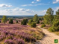
Il sentiero Heidschnuckenweg attraversa la Landa di Luneburgo, da Fischbek, alle porte di Amburgo, fino a Celle e al suo castello, e prende il nome dalle pecore con le corna che pascolano in greggi sulla brughiera. Percorre la più vasta distesa di brughiera del Nord Europa, la riserva senza auto intorno a Wilsede, ginepri nodosi e tranquille valli fluviali. A fine estate la fioritura dell'erica tinge di viola tutto il paesaggio.
Heidschnuckenweg: la mappa
La mappa interattiva mostra tutto il percorso, con alloggi, punti acqua e trasporti pubblici lungo il cammino.
Pianificatore di percorso: Heidschnuckenweg
Crea un itinerario giorno per giorno nel pianificatore, trova alloggi lungo il percorso e scarica il file GPX. Parti da un esempio qui sotto o da zero.
12-Day ItineraryMostrato sotto
The Heidschnuckenweg in twelve days built on the operator's stages, from the S-Bahn at Hamburg-Fischbek to the old town of Celle. The first day crosses the Fischbeker Heide and the beech woods of the Rosengarten to Dibbersen on the edge of Buchholz, and the second runs through Buchholz, past the Höllenschlucht and over the Brunsberg, then through the Büsenbachtal to Handeloh. The heath village of Wesel lies on the way to Undeloh, and from there the trail passes car-free Wilsede and climbs the Wilseder Berg, the high point of the walk, before dropping to Niederhaverbeck. The Behringer Heide leads to Bispingen, and the Luhe valley, past the river's source by the Timmerloher Heide, leads on to Soltau on the Böhme. Wietzendorf comes next, then a day over the Wietzer Berg, with its Löns memorial stone, to Müden on the Örtze. The short operator stage to Faßberg is folded into a day past Faßberg and through the juniper heath at Schmarbeck to Niederohe, by the Oberoher Heide, and the following day crosses the Haußelberg and passes Lutterloh on the way to Weesen. The Misselhorner Heide and the Tiefental lead to Dehningshof, a lone farmstead whose holiday farm, the Fuhrmanns-Schänke, serves no meals, so bring food for the evening and the next day. The last day is the operator's full final stage and the longest of the walk, past the Severloher Heide and the Wildecker Teiche and through the forest to Scheuen and Groß Hehlen, then along the Aller meadows into Celle.
Heidschnuckenweg: le tappe
12 giorni, 227 km e 1661 m di dislivello positivo. Queste tappe seguono l'itinerario «12-Day Itinerary». Aprilo nel pianificatore per dividere o unire le giornate e scegliere dove dormire.
- Tappa 120,4 km↑ 371 m · ↓ 264 m ·
6-7h con sosteVerso Dibbersen (Buchholz)
Notte a Sonnenblick - Tappa 221,3 km↑ 255 m · ↓ 313 m ·
6-7h con sosteDibbersen (Buchholz) Handeloh
Notte a Johmshof 1758 - Tappa 318,5 km↑ 128 m · ↓ 112 m ·
5-6h con sosteHandeloh Undeloh
Notte a Heiderose - Tappa 413,8 km↑ 141 m · ↓ 114 m ·
4-5h con sosteUndeloh Niederhaverbeck
Notte a Hotel Gasthof Menke - Tappa 516,7 km↑ 137 m · ↓ 165 m ·
5-6h con sosteNiederhaverbeck Bispingen
Notte a Flair Hotel Rieckmann Bispingen - Tappa 622,2 km↑ 109 m · ↓ 120 m ·
6-7h con sosteBispingen Soltau
Notte a Hotel Meyn - Tappa 721,3 km↑ 75 m · ↓ 73 m ·
6-7h con sosteSoltau Wietzendorf
Notte a Landgasthaus Wietzendorf - Gasthof - Tappa 814,1 km↑ 71 m · ↓ 78 m ·
4-5h con sosteWietzendorf Müden (Örtze)
Notte a Hotel Eichhornkobel - Tappa 917,0 km↑ 62 m · ↓ 41 m ·
4-5h con sosteMüden (Örtze) Niederohe
Notte a Haus Dübelsheide - Tappa 1021,2 km↑ 121 m · ↓ 139 m ·
6-7h con sosteNiederohe Weesen
Notte a Hotel- Restaurant „Im Wiesengrund“ GmbH & Co. KG - Tappa 1113,0 km↑ 106 m · ↓ 106 m ·
3-4h con sosteWeesen Dehningshof
Notte a Ferienhof Zur Alten Fuhrmanns-Schänke GmbH - Tappa 1227,3 km↑ 85 m · ↓ 108 m ·
7-8h con sosteDehningshof Celle
Quando andare
- Periodo migliore1 ago – 15 set
- Buon periodo1 mar – 31 lug, 16 set – 31 ott
- Possibile, con attenzione1 nov – 29 feb
Percorribile tutto l'anno: il sentiero si mantiene a bassa quota e non si allontana mai molto da un paese. L'erica fiorisce da inizio agosto a metà settembre, le settimane di maggiore affluenza nei villaggi della brughiera. Fuori dalla fioritura la brughiera è verde o bruna, ma in primavera nelle torbiere fiorisce l'erioforo e le greggi hanno gli agnelli, mentre l'autunno porta i suoi colori e sentieri più tranquilli. Da novembre a febbraio le ore di luce sono poche per le tappe più lunghe, che conviene iniziare presto, e sulla brughiera aperta possono esserci brina o neve.