
GR5
Conosciuto anche come Grande Traversée des Alpes
Informazioni su GR5
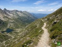
Una traversata continua delle Alpi francesi, dalle rive del lago di Ginevra al Mediterraneo a Nizza, conosciuta anche come Grande Traversée des Alpes. Il percorso scende verso sud attraverso lo Chablais, passa ai piedi del Monte Bianco e valica gli alti colli della Vanoise, del Queyras e del Mercantour, collegando rifugi di montagna e villaggi di fondovalle fino al mare.
GR5: la mappa
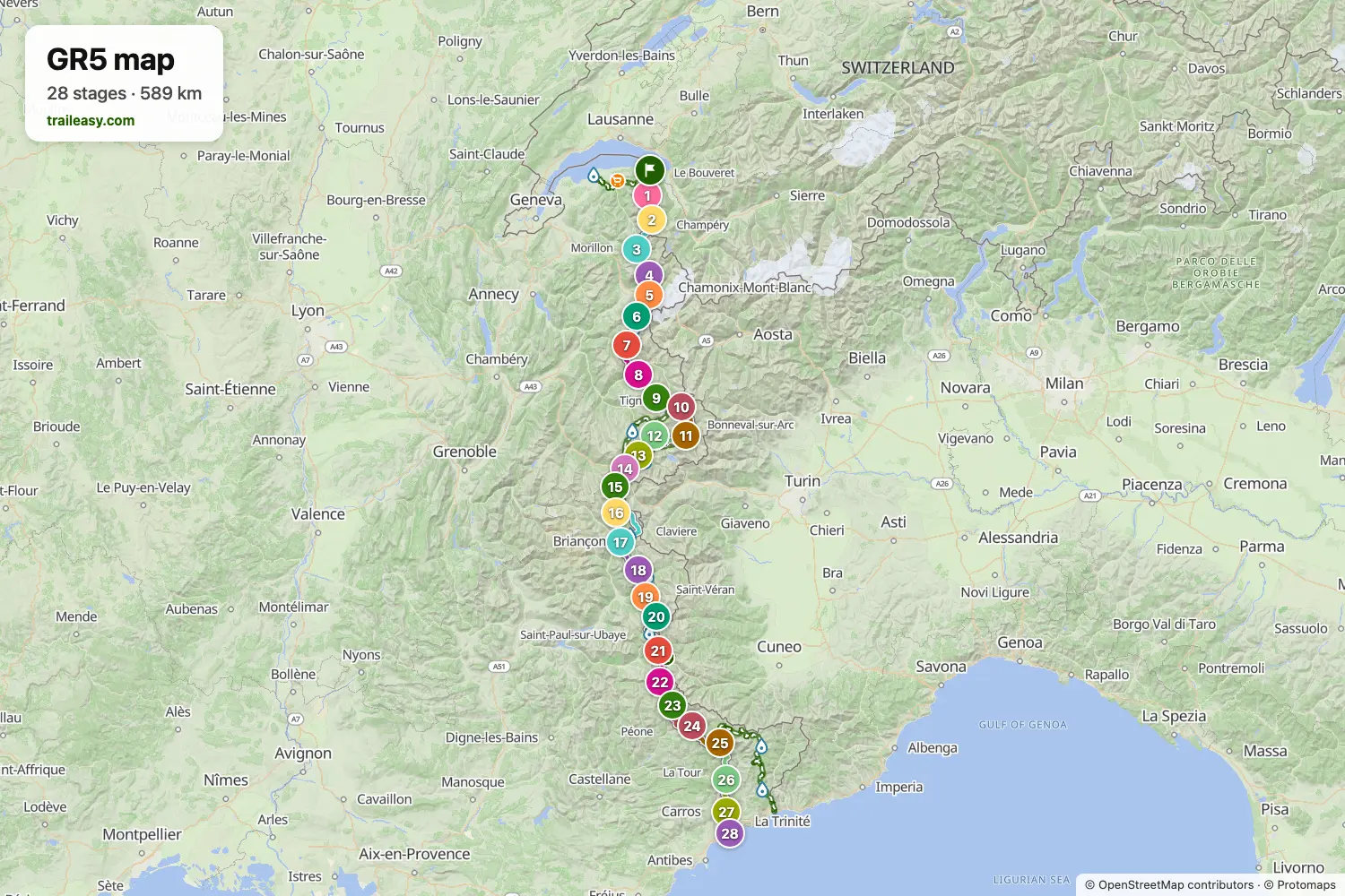
La mappa interattiva mostra tutto il percorso, con alloggi, punti acqua e trasporti pubblici lungo il cammino.
Pianificatore di percorso: GR5
Crea un itinerario giorno per giorno nel pianificatore, trova alloggi lungo il percorso e scarica il file GPX. Parti da un esempio qui sotto o da zero.
28-Day ItineraryMostrato sotto
The Grande Traversée des Alpes: the GR5 from the shore of Lake Geneva at St-Gingolph over the whole French Alps to the Mediterranean at Nice. It crosses the Chablais to the walls of the Mont Blanc massif, rounds the Vanoise glaciers by way of Val d'Isère and the Col de l'Iseran, then runs south through the Clarée, the Queyras and the Ubaye into the larch forests and perched villages of the Mercantour, finishing on the Promenade des Anglais. Refuge and village-inn nights the whole way, following the classic guidebook stages.
6-Day Itinerary
The opening week of the Grande Traversée des Alpes, from the shore of Lake Geneva at Saint-Gingolph to the Chamonix valley at Les Houches. The route climbs straight out of the lake into the Chablais, crosses the Portes du Soleil by way of Lac Vert and the Cols de Coux and de la Golèse, drops to Samoëns, then works up through the Sixt reserve to the Col d'Anterne, where the whole Mont Blanc massif opens up ahead. Nights in valley hotels and mountain refuges throughout, following the classic guidebook stages.
GR5: le tappe
28 giorni, 617 km e 35.070 m di dislivello positivo. Queste tappe seguono l'itinerario «28-Day Itinerary». Aprilo nel pianificatore per dividere o unire le giornate e scegliere dove dormire.
- Tappa 118,1 km↑ 1879 m · ↓ 1231 m ·
8-9h con sosteVerso La Chapelle-d'Abondance
Notte a Hôtel Restaurant l'Ensoleillé - Tappa 219,1 km↑ 1486 m · ↓ 526 m ·
7-8h con sosteLa Chapelle-d'Abondance Refuge de Chésery
Notte a Refuge de Chésery - Lac Vert - Tappa 324,3 km↑ 690 m · ↓ 1974 m ·
9-10h con sosteRefuge de Chésery Samoëns
Notte a AEC Vacances - Les Becchi, Samoëns - Tappa 420,9 km↑ 1850 m · ↓ 552 m ·
9-10h con sosteSamoëns Refuge de Moëde Anterne
Notte a Refuge Moëde Anterne - Tappa 518,8 km↑ 1055 m · ↓ 2017 m ·
8-9h con sosteRefuge de Moëde Anterne Les Houches
Notte a Chalet Hotel Les Campanules - Tappa 619,3 km↑ 1064 m · ↓ 936 m ·
7-8h con sosteLes Houches Les Contamines
Notte a Chalet-Hôtel La Chemenaz, The Originals Relais - Tappa 719,8 km↑ 1492 m · ↓ 836 m ·
8-9h con sosteLes Contamines Plan de la Lai
Notte a Refuge du Plan de la Lai - Tappa 827,2 km↑ 1086 m · ↓ 2168 m ·
10-11h con sostePlan de la Lai Landry
Notte a Camping l'Eden de la Vanoise - Tappa 918,7 km↑ 1564 m · ↓ 141 m ·
7-8h con sosteLandry Refuge d'Entre le Lac
Notte a Refuge d'Entre le Lac - Tappa 1018,5 km↑ 772 m · ↓ 1086 m ·
7-8h con sosteRefuge d'Entre le Lac Val d'Isère
Notte a Avancher Hôtel & Lodge - Restaurant & Bar - Massage & Coiffure - Tappa 1122,0 km↑ 1344 m · ↓ 1452 m ·
9-10h con sosteVal d'Isère Bessans
Notte a La Bessannaise - Tappa 1228,9 km↑ 1684 m · ↓ 1078 m ·
11-12h con sosteBessans Bellecombe (Plan du Lac)
Notte a Refuge de Bellecombe (l'auberge de Bellecombe) 2350m - Tappa 1331,0 km↑ 1442 m · ↓ 1599 m ·
12-13h con sosteBellecombe (Plan du Lac) Aussois
Notte a Le Montana - Tappa 1422,4 km↑ 766 m · ↓ 1893 m ·
8-9h con sosteAussois Modane
Notte a Hôtel Le Commerce - Tappa 1515,3 km↑ 1489 m · ↓ 49 m ·
6-7h con sosteModane Refuge du Mont Thabor
Notte a Refuge du Mont Thabor - Tappa 1618,1 km↑ 498 m · ↓ 1372 m ·
6-7h con sosteRefuge du Mont Thabor Névache
Notte a Auberge du Clot - Tappa 1732,8 km↑ 1345 m · ↓ 1752 m ·
12-13h con sosteNévache Briançon
Notte a SOWELL HÔTELS LE PARC & SPA - Tappa 1819,5 km↑ 1341 m · ↓ 875 m ·
8-9h con sosteBriançon Brunissard
Notte a Logis Hôtel la Ferme de l'Izoard & Spa - Tappa 1921,6 km↑ 1398 m · ↓ 1406 m ·
9-10h con sosteBrunissard Ceillac
Notte a VVF Queyras - Tappa 2014,5 km↑ 1159 m · ↓ 927 m ·
6-7h con sosteCeillac Maljasset
Notte a Refuge Chalet CAF de Maljasset - Tappa 2127,9 km↑ 1785 m · ↓ 2006 m ·
11-12h con sosteMaljasset Larche
Notte a Auberge du Lauzanier - Tappa 2220,3 km↑ 1247 m · ↓ 1051 m ·
8-9h con sosteLarche Bousiéyas
Notte a Refuge - Tappa 2322,5 km↑ 1249 m · ↓ 1535 m ·
9-10h con sosteBousiéyas Auron
Notte a Hôtel Edelweiss Auron - Tappa 2427,6 km↑ 1835 m · ↓ 1544 m ·
11-12h con sosteAuron Refuge de Longon
Notte a Refuge Longon - Tappa 2524,7 km↑ 1112 m · ↓ 1667 m ·
9-10h con sosteRefuge de Longon St-Dalmas-Valdeblore
Notte a Maison d'hôtes Les Murès du Mercantour - Tappa 2626,0 km↑ 1270 m · ↓ 1788 m ·
10-11h con sosteSt-Dalmas-Valdeblore Utelle
Notte a Le Bellevue Martinon - Tappa 2723,2 km↑ 950 m · ↓ 1265 m ·
8-9h con sosteUtelle Aspremont
Notte a Hostellerie Aspremont - Tappa 2813,9 km↑ 218 m · ↓ 713 m ·
4-5h con sosteAspremont Nice
Quando andare
- Periodo migliore16 lug – 15 set
- Possibile, con attenzione16 giu – 15 lug, 16 set – 30 set
Da metà luglio a metà settembre è il periodo affidabile, con i refuges custoditi per tutto il percorso. I valichi più alti, soprattutto il Col de l'Iseran e il Col de Chavière, possono trattenere neve fino ai primi di luglio, e qui pochi portano la piccozza, per cui partire troppo presto trasforma passaggi semplici in un problema. Da metà settembre i refuges chiudono e restano i locali invernali incustoditi e i posti letto a fondovalle.