
Tour du Mont Blanc
À propos de Tour du Mont Blanc
Cette boucle emblématique de 170 km fait le tour du plus haut sommet d'Europe occidentale, traversant des alpages, des vallées glaciaires et des cols de montagne à travers trois pays. L'itinéraire offre des vues spectaculaires sur le massif glaciaire du Mont Blanc et relie de charmants villages de montagne.
Tour du Mont Blanc : la carte
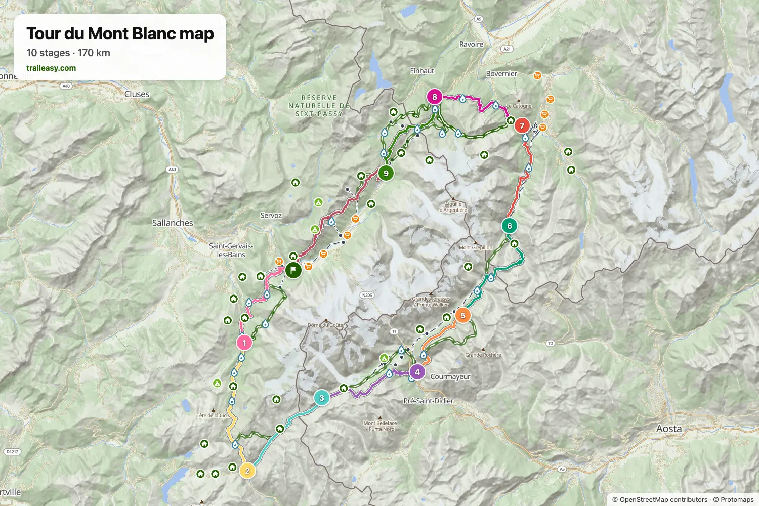
La carte interactive montre tout le parcours, avec les hébergements, les points d'eau et les transports en commun le long du chemin.
Planificateur d'itinéraire Tour du Mont Blanc
Créez un itinéraire jour par jour dans le planificateur, trouvez des hébergements le long du parcours et téléchargez le fichier GPX. Partez d'un exemple ci-dessous ou de zéro.
10-Day ItineraryAffiché ci-dessous
A relaxed 10-day counter-clockwise Tour du Mont Blanc circuit through France, Italy, and Switzerland. This classic route splits the Col de la Seigne crossing with a memorable night at Rifugio Elisabetta, offering stunning views of the Aiguille des Glaciers and Mont Blanc massif.
8-Day Itinerary
The Tour du Mont Blanc counter-clockwise from Les Houches in eight days, for walkers who are happy with long stages. The first day carries on past Les Contamines to the Refuge de Nant Borrant, which shortens the crossing of the Col du Bonhomme to the Refuge des Mottets the next day. From there the route goes over the Col de la Seigne into Italy and down to Courmayeur, follows the balcony above the Italian Val Ferret to Rifugio Elena, and crosses the Grand Col Ferret to Champex-Lac in one stage. The last three days take the Bovine path to Trient, the Col de Balme to the Refuge de La Flégère, and the Brévent back to Les Houches.
Tour du Mont Blanc in 9 Days
The Tour du Mont Blanc counter-clockwise through France, Italy and Switzerland in nine days, with the long stages split at huts along the way: Rifugio Elisabetta below Col de la Seigne, Rifugio Bertone above Courmayeur and Alpage de la Peule past Grand Col Ferret. The last two days cross Col de Balme to the Refuge de La Flégère, facing the Mont Blanc massif, and finish over the Brévent at Les Houches.
9-Day Itinerary Camping
This classic counter-clockwise Tour du Mont Blanc circuit covers 182 km over 9 days, starting and finishing in Les Houches with a campsite every night. From Les Contamines it climbs the Col du Bonhomme to Les Chapieux, crosses the Col de la Seigne into Italy's Val Veny beneath the Mont Blanc massif, follows the high balcony past the Grandes Jorasses to Val Ferret, then traverses the Grand Col Ferret into Switzerland via La Fouly, Champex-Lac and Trient before the Col de Balme and the Grand Balcon Sud under Le Brevent bring it back to Les Houches. It is a tent hiker's campsite-to-campsite split, with three big pass days (Col de la Seigne, Grand Col Ferret and the final Flegere-Brevent traverse) offset by shorter valley stages in between.
Classic 11-Day Tour du Mont Blanc
The complete counter-clockwise circuit around Mont Blanc, the highest peak in the Alps. This 170km trek passes through France, Italy, and Switzerland, crossing stunning alpine passes with views of glaciers, dramatic peaks, and charming mountain villages. Starting from Chamonix, this 11-day itinerary follows the most popular route with comfortable accommodation in hotels, auberges, and mountain refuges.
L’avis des randonneurs vérifiés
Tour du Mont Blanc : les étapes
10 jours, 169 km et 10 466 m de dénivelé positif. Ces étapes suivent l'itinéraire « 10-Day Itinerary ». Ouvrez-le dans le planificateur pour couper ou fusionner des journées et choisir où dormir.
- Étape 117,3 km↑ 1 108 m · ↓ 933 m ·
7–8h avec pausesLes Houches Les Contamines-Montjoie
Nuit à Chalet Hotel Gai Soleil - Étape 219,0 km↑ 1 381 m · ↓ 1 010 m ·
8–9h avec pausesLes Contamines-Montjoie Les Chapieux
Nuit à Auberge de la Nova - Étape 313,9 km↑ 1 039 m · ↓ 404 m ·
5–6h avec pausesLes Chapieux Rifugio Elisabetta
Nuit à Rifugio Elisabetta - Étape 416,2 km↑ 549 m · ↓ 1 528 m ·
6–7h avec pausesRifugio Elisabetta Courmayeur
Nuit à Hotel Bouton d'Or - Courmayeur - Étape 512,0 km↑ 1 098 m · ↓ 277 m ·
5–6h avec pausesCourmayeur Rifugio Bonatti
Nuit à Rifugio Walter Bonatti - Étape 619,5 km↑ 958 m · ↓ 1 384 m ·
7–8h avec pausesRifugio Bonatti La Fouly
Nuit à Hotel Edelweiss La Fouly - Étape 714,9 km↑ 539 m · ↓ 667 m ·
5–6h avec pausesLa Fouly Champex-Lac
Nuit à Hôtel spa Au Club Alpin - Étape 816,2 km↑ 839 m · ↓ 1 034 m ·
6–7h avec pausesChampex-Lac Trient
Nuit à The Auberge du Mont Blanc - Étape 915,2 km↑ 1 151 m · ↓ 1 170 m ·
6–7h avec pausesTrient Argentière
Nuit à Hôtel de La Couronne - Étape 1024,8 km↑ 1 804 m · ↓ 2 055 m ·
11–12h avec pausesArgentière Les Houches
Quand partir
- Meilleure période1 juil. – 15 sept.
- Bonne période16 juin – 30 juin
- Possible, avec prudence16 sept. – 15 oct.
Les refuges ouvrent à la mi-juin et ferment à la mi-septembre. Les cols élevés gardent la neige jusqu'au début juillet, consultez les conditions publiées et interrogez les refuges avant un départ précoce. Août est le mois le plus fréquenté et les places partent des mois à l'avance. À partir de la mi-septembre, seuls les hôtels de vallée restent ouverts et la neige est possible sur les cols.