
Tour du Mont Blanc
Sobre Tour du Mont Blanc
Este icónico circuito de 170 km rodea el pico más alto de Europa occidental, atravesando prados alpinos, valles glaciares y puertos de montaña en tres países. La ruta ofrece vistas espectaculares del macizo glaciar del Mont Blanc y conecta encantadores pueblos de montaña.
Tour du Mont Blanc: mapa
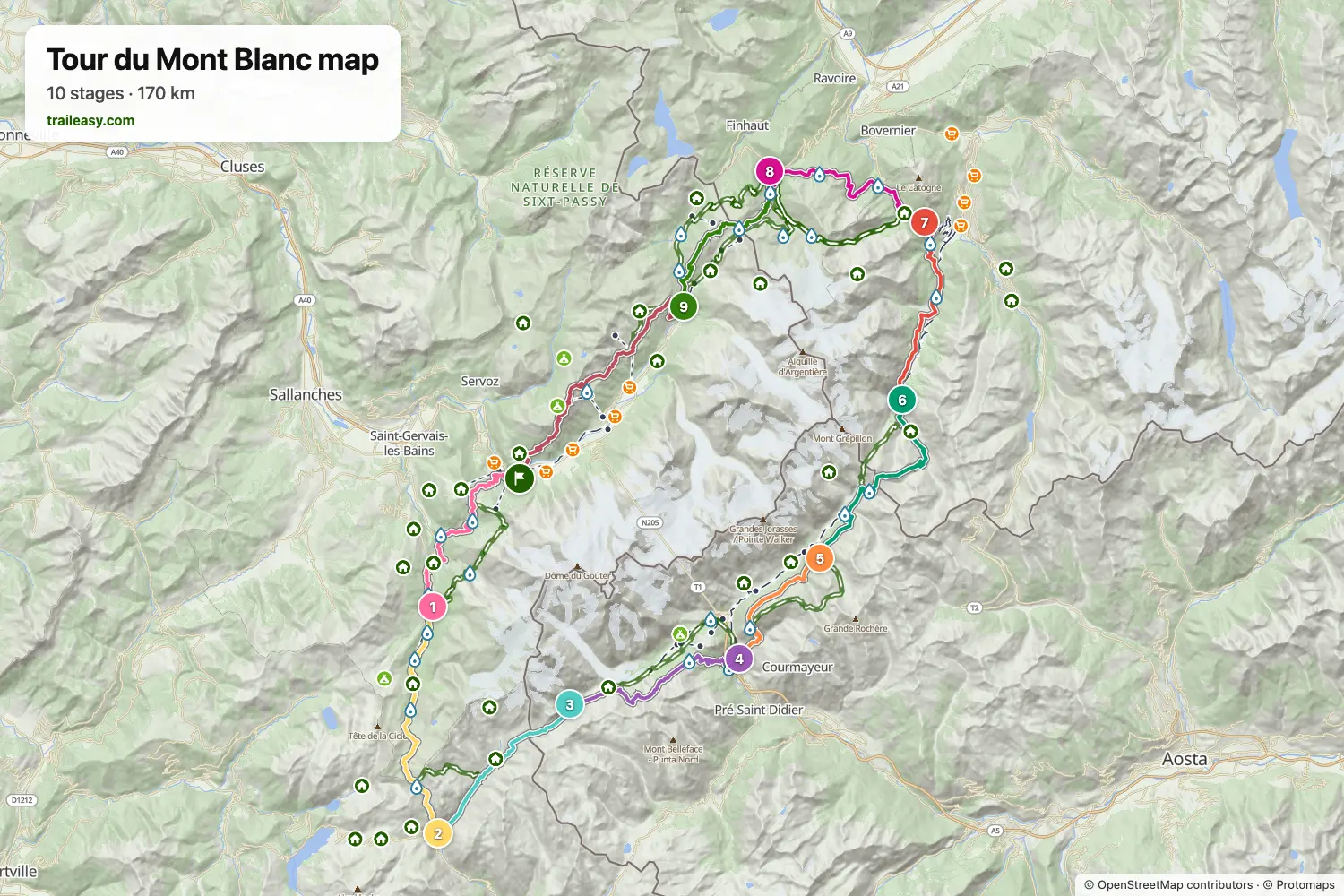
El mapa interactivo muestra toda la ruta, con alojamientos, puntos de agua y transporte público a lo largo del camino.
Planificador de ruta: Tour du Mont Blanc
Crea un itinerario día a día en el planificador de ruta, encuentra alojamientos a lo largo de la ruta y descarga el archivo GPX. Empieza con un ejemplo abajo o desde cero.
10-Day ItineraryMostrado abajo
A relaxed 10-day counter-clockwise Tour du Mont Blanc circuit through France, Italy, and Switzerland. This classic route splits the Col de la Seigne crossing with a memorable night at Rifugio Elisabetta, offering stunning views of the Aiguille des Glaciers and Mont Blanc massif.
8-Day Itinerary
The Tour du Mont Blanc counter-clockwise from Les Houches in eight days, for walkers who are happy with long stages. The first day carries on past Les Contamines to the Refuge de Nant Borrant, which shortens the crossing of the Col du Bonhomme to the Refuge des Mottets the next day. From there the route goes over the Col de la Seigne into Italy and down to Courmayeur, follows the balcony above the Italian Val Ferret to Rifugio Elena, and crosses the Grand Col Ferret to Champex-Lac in one stage. The last three days take the Bovine path to Trient, the Col de Balme to the Refuge de La Flégère, and the Brévent back to Les Houches.
Tour du Mont Blanc in 9 Days
The Tour du Mont Blanc counter-clockwise through France, Italy and Switzerland in nine days, with the long stages split at huts along the way: Rifugio Elisabetta below Col de la Seigne, Rifugio Bertone above Courmayeur and Alpage de la Peule past Grand Col Ferret. The last two days cross Col de Balme to the Refuge de La Flégère, facing the Mont Blanc massif, and finish over the Brévent at Les Houches.
9-Day Itinerary Camping
This classic counter-clockwise Tour du Mont Blanc circuit covers 182 km over 9 days, starting and finishing in Les Houches with a campsite every night. From Les Contamines it climbs the Col du Bonhomme to Les Chapieux, crosses the Col de la Seigne into Italy's Val Veny beneath the Mont Blanc massif, follows the high balcony past the Grandes Jorasses to Val Ferret, then traverses the Grand Col Ferret into Switzerland via La Fouly, Champex-Lac and Trient before the Col de Balme and the Grand Balcon Sud under Le Brevent bring it back to Les Houches. It is a tent hiker's campsite-to-campsite split, with three big pass days (Col de la Seigne, Grand Col Ferret and the final Flegere-Brevent traverse) offset by shorter valley stages in between.
Classic 11-Day Tour du Mont Blanc
The complete counter-clockwise circuit around Mont Blanc, the highest peak in the Alps. This 170km trek passes through France, Italy, and Switzerland, crossing stunning alpine passes with views of glaciers, dramatic peaks, and charming mountain villages. Starting from Chamonix, this 11-day itinerary follows the most popular route with comfortable accommodation in hotels, auberges, and mountain refuges.
Lo que dicen los senderistas verificados
Tour du Mont Blanc: etapas
10 días, 169 km y 10.466 m de desnivel positivo. Estas etapas siguen el itinerario «10-Day Itinerary». Ábrelo en el planificador para dividir o unir días y elegir dónde dormir.
- Etapa 117,3 km↑ 1108 m · ↓ 933 m ·
7-8h con paradasLes Houches Les Contamines-Montjoie
Noche en Chalet Hotel Gai Soleil - Etapa 219,0 km↑ 1381 m · ↓ 1010 m ·
8-9h con paradasLes Contamines-Montjoie Les Chapieux
Noche en Auberge de la Nova - Etapa 313,9 km↑ 1039 m · ↓ 404 m ·
5-6h con paradasLes Chapieux Rifugio Elisabetta
Noche en Rifugio Elisabetta - Etapa 416,2 km↑ 549 m · ↓ 1528 m ·
6-7h con paradasRifugio Elisabetta Courmayeur
Noche en Hotel Bouton d'Or - Courmayeur - Etapa 512,0 km↑ 1098 m · ↓ 277 m ·
5-6h con paradasCourmayeur Rifugio Bonatti
Noche en Rifugio Walter Bonatti - Etapa 619,5 km↑ 958 m · ↓ 1384 m ·
7-8h con paradasRifugio Bonatti La Fouly
Noche en Hotel Edelweiss La Fouly - Etapa 714,9 km↑ 539 m · ↓ 667 m ·
5-6h con paradasLa Fouly Champex-Lac
Noche en Hôtel spa Au Club Alpin - Etapa 816,2 km↑ 839 m · ↓ 1034 m ·
6-7h con paradasChampex-Lac Trient
Noche en The Auberge du Mont Blanc - Etapa 915,2 km↑ 1151 m · ↓ 1170 m ·
6-7h con paradasTrient Argentière
Noche en Hôtel de La Couronne - Etapa 1024,8 km↑ 1804 m · ↓ 2055 m ·
11-12h con paradasArgentière Les Houches
Cuándo ir
- Mejor época1 jul – 15 sept
- Buena época16 jun – 30 jun
- Posible, con precaución16 sept – 15 oct
Los refugios abren a mediados de junio y cierran a mediados de septiembre. Los collados altos conservan nieve hasta principios de julio, conviene consultar el parte de condiciones y preguntar en los refugios antes de salir pronto. Agosto es el mes de más afluencia y las plazas se agotan con meses de antelación. Desde mediados de septiembre solo quedan abiertos los hoteles del valle y puede nevar en los puertos.