
South West Coast Path
Sobre South West Coast Path
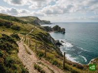
Uno de los senderos nacionales más largos de Inglaterra, que bordea la costa desde Minehead en Somerset alrededor de las penínsulas de Devon, Cornualles y Dorset hasta finalizar en Poole Harbour. La ruta serpentea junto a espectaculares acantilados marinos, calas aisladas, pueblos pesqueros, playas de arena y la Costa Jurásica, con ascensos y descensos incesantes que rivalizan con muchas travesías de montaña.
South West Coast Path: mapa
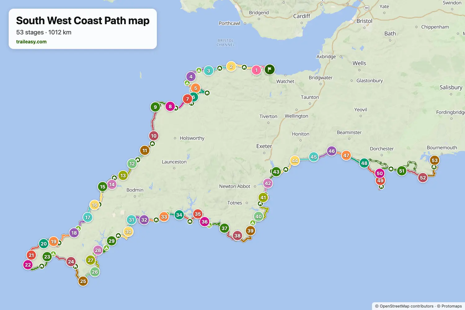
El mapa interactivo muestra toda la ruta, con alojamientos, puntos de agua y transporte público a lo largo del camino.
Planificador de ruta: South West Coast Path
Crea un itinerario día a día en el planificador de ruta, encuentra alojamientos a lo largo de la ruta y descarga el archivo GPX. Empieza con un ejemplo abajo o desde cero.
53 Day Full ItineraryMostrado abajo
A end-to-end traverse of the South West Coast Path National Trail across 53 daily stages, from Minehead in Somerset to South Haven Point on Studland Heath in Dorset. The first half threads the Exmoor cliffs and North Cornwall's surf coast through Lynmouth, Hartland Quay, Tintagel and Padstow, then loops Land's End via Sennen Cove and Penzance. The second half traces Cornwall's south coast through the Lizard, Falmouth and the Roseland to Fowey and Looe, crosses Plymouth Sound, then climbs the South Devon cliffs to Salcombe and Dartmouth before easing along the Riviera to Exmouth and onto the Jurassic Coast — Lyme Regis, Weymouth, Lulworth Cove and the Purbeck headlands before the final cliffs above Old Harry Rocks. Day splits follow the National Trail's recommended pacing, with longer routed distances on stages where the trail's tidal-river ferries are bypassed.
St Ives to Plymouth (Section 2)
The Cornish corner of the South West Coast Path, 16 days from St Ives to Plymouth. The opening stretch crosses the granite Penwith peninsula past Iron Age field walls and abandoned engine houses to Land's End, then turns east. The south coast feels different from the north — lower cliffs, sandy coves, and a sheltered, near-sub-tropical microclimate around Penzance and the Helford river. The Lizard peninsula reaches mainland Britain's most southerly point over its distinctive serpentine cliffs. From Falmouth onwards progress is repeatedly broken by tidal estuaries crossed by small passenger ferries. The section ends across the Tamar into Plymouth.
Plymouth to Studland (Section 3)
South Devon and the Jurassic Coast, 18 days from Plymouth to the trail's end at Studland. The South Devon cliffs from Plymouth past Salcombe and Start Point are steep and remote again after the gentler south Cornish coast, broken by the long shingle line of Slapton Sands. East of Exmouth the trail follows the Jurassic Coast — a World Heritage Site where the cliffs cycle through Triassic red sandstone with fossil beaches at Charmouth and Lyme Regis. The final week features the long Chesil Beach shingle barrier, the limestone bulk of the Isle of Portland, the cove and arch at Lulworth and Durdle Door, and the chalk stacks of Old Harry Rocks before the trail terminus at South Haven Point on Studland Heath, opposite Sandbanks across the mouth of Poole Harbour.
Minehead to St Ives (Section 1)
The first and most strenuous stretch of the South West Coast Path, 19 days from Minehead to St Ives. The route climbs straight onto the Exmoor coast and crosses Great Hangman, the highest sea cliff on mainland England. After easier ground around the Taw and Torridge estuaries and the long sands at Woolacombe, the Hartland coast delivers the toughest walking on the entire trail: a relentless in-and-out profile through steep wooded combes, with few road crossings and full Atlantic exposure. South of Bude the path follows North Cornwall's slate cliffs and surf beaches through old tin and copper mining country before finishing at St Ives.
South West Coast Path: etapas
53 días, 1062 km y 33.887 m de desnivel positivo. Estas etapas siguen el itinerario «53 Day Full Itinerary». Ábrelo en el planificador para dividir o unir días y elegir dónde dormir.
- Etapa 114,6 km↑ 497 m · ↓ 468 m ·
5-6h con paradasHacia Porlock
Noche en Myrtle Cottage - Etapa 221,9 km↑ 933 m · ↓ 961 m ·
8-9h con paradasPorlock Lynmouth
Noche en The Rising Sun - Etapa 322,2 km↑ 1015 m · ↓ 994 m ·
8-9h con paradasLynmouth Combe Martin
Noche en John Fowler Holidays - Combe Martin Beach - Etapa 422,5 km↑ 992 m · ↓ 1001 m ·
8-9h con paradasCombe Martin Woolacombe
Noche en Woolacombe Bay Hotel - Etapa 524,3 km↑ 295 m · ↓ 305 m ·
7-8h con paradasWoolacombe Braunton
Noche en Stockwell Lodge - Etapa 619,0 km↑ 30 m · ↓ 29 m ·
5-6h con paradasBraunton Instow
Noche en Commodore Instow - Etapa 717,8 km↑ 125 m · ↓ 124 m ·
5-6h con paradasInstow Westward Ho!
Noche en The Waterfront Inn - Etapa 819,0 km↑ 742 m · ↓ 745 m ·
6-7h con paradasWestward Ho! Clovelly
Noche en The Red Lion Hotel - Etapa 916,7 km↑ 749 m · ↓ 741 m ·
6-7h con paradasClovelly Hartland Quay
Noche en Hartland Quay Hotel - Etapa 1024,9 km↑ 1103 m · ↓ 1115 m ·
9-10h con paradasHartland Quay Bude
Noche en The Brendon Arms - Etapa 1116,7 km↑ 709 m · ↓ 702 m ·
6-7h con paradasBude Crackington Haven
Noche en The Coombe Barton Inn - Etapa 1218,3 km↑ 990 m · ↓ 914 m ·
7-8h con paradasCrackington Haven Tintagel
Noche en King Arthur's Arms Hotel - Etapa 1316,3 km↑ 818 m · ↓ 893 m ·
6-7h con paradasTintagel Port Isaac
Noche en The Old School Hotel - Etapa 1420,8 km↑ 794 m · ↓ 806 m ·
7-8h con paradasPort Isaac Padstow
Noche en Old Custom House, Padstow - Etapa 1518,2 km↑ 351 m · ↓ 341 m ·
5-6h con paradasPadstow Porthcothan
Noche en YHA Treyarnon Bay - Etapa 1623,3 km↑ 747 m · ↓ 736 m ·
8-9h con paradasPorthcothan Newquay
Noche en The Headland - Etapa 1721,1 km↑ 527 m · ↓ 505 m ·
7-8h con paradasNewquay Perranporth
Noche en YHA Perranporth - Etapa 1819,8 km↑ 668 m · ↓ 637 m ·
7-8h con paradasPerranporth Portreath
Noche en Gwel an Mor Resort - Etapa 1929,2 km↑ 852 m · ↓ 839 m ·
10-11h con paradasPortreath St Ives
Noche en Tregenna Castle Resort - Etapa 2012,8 km↑ 477 m · ↓ 460 m ·
4-5h con paradasSt Ives Zennor
Noche en White House Zennor - Etapa 2123,1 km↑ 834 m · ↓ 818 m ·
8-9h con paradasZennor St Just
Noche en The Old Post House B&B - Etapa 229,9 km↑ 295 m · ↓ 348 m ·
3-4h con paradasSt Just Sennen Cove
Noche en The Land's End Hotel - Etapa 2325,3 km↑ 887 m · ↓ 950 m ·
9-10h con paradasSennen Cove Penzance
Noche en Queens Hotel - Etapa 2423,6 km↑ 597 m · ↓ 597 m ·
7-8h con paradasPenzance Porthleven
Noche en Harbour Inn, Porthleven - Etapa 2524,5 km↑ 782 m · ↓ 714 m ·
8-9h con paradasPorthleven The Lizard
Noche en The Top House Inn - Etapa 2616,4 km↑ 528 m · ↓ 592 m ·
5-6h con paradasThe Lizard Coverack
Noche en Paris Hotel - Etapa 2721,3 km↑ 670 m · ↓ 671 m ·
7-8h con paradasCoverack Helford
Noche en Shipwrights Arms - Etapa 2816,6 km↑ 400 m · ↓ 404 m ·
5-6h con paradasHelford Falmouth
Noche en Chain Locker, Falmouth - Etapa 2921,9 km↑ 455 m · ↓ 436 m ·
7-8h con paradasFalmouth Portscatho
Noche en The Nare Hotel - Etapa 3024,9 km↑ 1011 m · ↓ 1031 m ·
9-10h con paradasPortscatho Mevagissey
Noche en The Rising Sun Inn - Etapa 3112,8 km↑ 655 m · ↓ 651 m ·
5-6h con paradasMevagissey Charlestown
Noche en Pier House Hotel, Charlestown - Etapa 3216,4 km↑ 520 m · ↓ 514 m ·
5-6h con paradasCharlestown Fowey
Noche en Tides Reach - Etapa 3319,7 km↑ 789 m · ↓ 774 m ·
7-8h con paradasFowey Looe
Noche en The Gulls - Etapa 3413,3 km↑ 531 m · ↓ 540 m ·
4-5h con paradasLooe Portwrinkle
Noche en The Nooke - Etapa 3526,8 km↑ 611 m · ↓ 615 m ·
8-9h con paradasPortwrinkle Plymouth
Noche en Crowne Plaza Plymouth by IHG - Etapa 3620,2 km↑ 452 m · ↓ 413 m ·
6-7h con paradasPlymouth Wembury
Noche en Sea Breeze Wembury Beach - Three-Bedroom House - Etapa 3725,1 km↑ 766 m · ↓ 803 m ·
8-9h con paradasWembury Bigbury-on-Sea
Noche en Coastguards - Four-Bedroom House - Etapa 3821,8 km↑ 776 m · ↓ 744 m ·
7-8h con paradasBigbury-on-Sea Salcombe
Noche en The Fo'c'sle & Pengwern - Etapa 3922,0 km↑ 726 m · ↓ 779 m ·
7-8h con paradasSalcombe Torcross
Noche en Reeds - Etapa 4015,9 km↑ 495 m · ↓ 497 m ·
5-6h con paradasTorcross Dartmouth
Noche en The Royal Castle - Etapa 4131,0 km↑ 1208 m · ↓ 1199 m ·
11-12h con paradasDartmouth Torquay
Noche en Premier Inn Torquay Seafront hotel - Etapa 4220,1 km↑ 942 m · ↓ 946 m ·
7-8h con paradasTorquay Teignmouth
Noche en The Thornhill - Etapa 4315,5 km↑ 143 m · ↓ 143 m ·
4-5h con paradasTeignmouth Exmouth
Noche en Premier Inn Exmouth Seafront hotel - Etapa 4420,6 km↑ 556 m · ↓ 545 m ·
7-8h con paradasExmouth Sidmouth
Noche en Woodlands Hotel Sidmouth - Etapa 4517,2 km↑ 698 m · ↓ 707 m ·
6-7h con paradasSidmouth Seaton
Noche en Mariners Hotel - Etapa 4617,7 km↑ 622 m · ↓ 612 m ·
6-7h con paradasSeaton Charmouth
Noche en Hensleigh House - Etapa 4711,5 km↑ 597 m · ↓ 609 m ·
4-5h con paradasCharmouth West Bay
Noche en 2 Bed in West Bay (oc-d31037) - Etapa 4815,8 km↑ 176 m · ↓ 138 m ·
4-5h con paradasWest Bay Abbotsbury
Noche en The Ilchester Arms Abbotsbury - Etapa 4921,2 km↑ 263 m · ↓ 303 m ·
6-7h con paradasAbbotsbury Fortuneswell
Noche en The Bunker - Etapa 5023,5 km↑ 441 m · ↓ 433 m ·
7-8h con paradasFortuneswell Weymouth
Noche en Fishermans Cottage - Etapa 5119,5 km↑ 675 m · ↓ 669 m ·
6-7h con paradasWeymouth Lulworth Cove
Noche en Lulworth Holiday Cottage - Etapa 5222,7 km↑ 939 m · ↓ 851 m ·
8-9h con paradasLulworth Cove Worth Matravers
Noche en 4 Bed in Worth Matravers oc-ic036 - Etapa 5325,1 km↑ 433 m · ↓ 541 m ·
8-9h con paradasWorth Matravers Studland
Cuándo ir
- Mejor época1 abr – 30 jun, 1 sept – 30 sept
- Buena época1 mar – 31 mar, 1 jul – 31 ago, 1 oct – 31 oct
- Posible, con precaución1 nov – 29 feb
De abril a junio y en septiembre son los mejores meses en los acantilados, con flores silvestres, días largos y todos los transbordadores de estuario en marcha. Julio y agosto son calurosos en los tramos expuestos y los pueblos costeros de Cornualles están a rebosar. De noviembre a febrero varios transbordadores paran por el invierno, y cada uno perdido supone un largo rodeo tierra adentro, además de los temporales y la poca luz.