
Tour du Mont Blanc
Über Tour du Mont Blanc
Diese ikonische 170 km lange Rundwanderung umkreist den höchsten Gipfel Westeuropas und führt durch Almwiesen, Gletschertäler und Bergpässe in drei Ländern. Die Route bietet spektakuläre Ausblicke auf das mächtige vergletscherte Mont-Blanc-Massiv und verbindet malerische Bergdörfer.
Tour du Mont Blanc: Karte
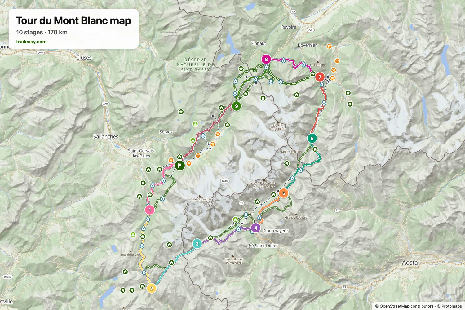
Die interaktive Karte zeigt den gesamten Weg mit Unterkünften, Wasserstellen und öffentlichen Verkehrsmitteln entlang der Strecke.
Tourenplaner Tour du Mont Blanc
Erstelle im Tourenplaner eine Etappenroute, finde Unterkünfte entlang der Strecke und lade die GPX-Datei herunter. Starte mit einem Beispiel unten oder von vorn.
10-Day ItineraryUnten gezeigt
A relaxed 10-day counter-clockwise Tour du Mont Blanc circuit through France, Italy, and Switzerland. This classic route splits the Col de la Seigne crossing with a memorable night at Rifugio Elisabetta, offering stunning views of the Aiguille des Glaciers and Mont Blanc massif.
8-Day Itinerary
The Tour du Mont Blanc counter-clockwise from Les Houches in eight days, for walkers who are happy with long stages. The first day carries on past Les Contamines to the Refuge de Nant Borrant, which shortens the crossing of the Col du Bonhomme to the Refuge des Mottets the next day. From there the route goes over the Col de la Seigne into Italy and down to Courmayeur, follows the balcony above the Italian Val Ferret to Rifugio Elena, and crosses the Grand Col Ferret to Champex-Lac in one stage. The last three days take the Bovine path to Trient, the Col de Balme to the Refuge de La Flégère, and the Brévent back to Les Houches.
Tour du Mont Blanc in 9 Days
The Tour du Mont Blanc counter-clockwise through France, Italy and Switzerland in nine days, with the long stages split at huts along the way: Rifugio Elisabetta below Col de la Seigne, Rifugio Bertone above Courmayeur and Alpage de la Peule past Grand Col Ferret. The last two days cross Col de Balme to the Refuge de La Flégère, facing the Mont Blanc massif, and finish over the Brévent at Les Houches.
9-Day Itinerary Camping
This classic counter-clockwise Tour du Mont Blanc circuit covers 182 km over 9 days, starting and finishing in Les Houches with a campsite every night. From Les Contamines it climbs the Col du Bonhomme to Les Chapieux, crosses the Col de la Seigne into Italy's Val Veny beneath the Mont Blanc massif, follows the high balcony past the Grandes Jorasses to Val Ferret, then traverses the Grand Col Ferret into Switzerland via La Fouly, Champex-Lac and Trient before the Col de Balme and the Grand Balcon Sud under Le Brevent bring it back to Les Houches. It is a tent hiker's campsite-to-campsite split, with three big pass days (Col de la Seigne, Grand Col Ferret and the final Flegere-Brevent traverse) offset by shorter valley stages in between.
Classic 11-Day Tour du Mont Blanc
The complete counter-clockwise circuit around Mont Blanc, the highest peak in the Alps. This 170km trek passes through France, Italy, and Switzerland, crossing stunning alpine passes with views of glaciers, dramatic peaks, and charming mountain villages. Starting from Chamonix, this 11-day itinerary follows the most popular route with comfortable accommodation in hotels, auberges, and mountain refuges.
Das sagen verifizierte Wanderer
Tour du Mont Blanc: Etappen
10 Tage, 169 km und 10.466 m Aufstieg. Die Etappen folgen der Beispielroute „10-Day Itinerary“. Öffne sie im Tourenplaner, um Tage zu teilen oder zusammenzulegen und Unterkünfte zu wählen.
- Etappe 117,3 km↑ 1.108 m · ↓ 933 m ·
7–8h mit PausenLes Houches Les Contamines-Montjoie
Übernachtung: Chalet Hotel Gai Soleil - Etappe 219,0 km↑ 1.381 m · ↓ 1.010 m ·
8–9h mit PausenLes Contamines-Montjoie Les Chapieux
Übernachtung: Auberge de la Nova - Etappe 313,9 km↑ 1.039 m · ↓ 404 m ·
5–6h mit PausenLes Chapieux Rifugio Elisabetta
Übernachtung: Rifugio Elisabetta - Etappe 416,2 km↑ 549 m · ↓ 1.528 m ·
6–7h mit PausenRifugio Elisabetta Courmayeur
Übernachtung: Hotel Bouton d'Or - Courmayeur - Etappe 512,0 km↑ 1.098 m · ↓ 277 m ·
5–6h mit PausenCourmayeur Rifugio Bonatti
Übernachtung: Rifugio Walter Bonatti - Etappe 619,5 km↑ 958 m · ↓ 1.384 m ·
7–8h mit PausenRifugio Bonatti La Fouly
Übernachtung: Hotel Edelweiss La Fouly - Etappe 714,9 km↑ 539 m · ↓ 667 m ·
5–6h mit PausenLa Fouly Champex-Lac
Übernachtung: Hôtel spa Au Club Alpin - Etappe 816,2 km↑ 839 m · ↓ 1.034 m ·
6–7h mit PausenChampex-Lac Trient
Übernachtung: The Auberge du Mont Blanc - Etappe 915,2 km↑ 1.151 m · ↓ 1.170 m ·
6–7h mit PausenTrient Argentière
Übernachtung: Hôtel de La Couronne - Etappe 1024,8 km↑ 1.804 m · ↓ 2.055 m ·
11–12h mit PausenArgentière Les Houches
Beste Reisezeit
- Beste Zeit1. Juli – 15. Sept.
- Gute Zeit16. Juni – 30. Juni
- Möglich, mit Vorsicht16. Sept. – 15. Okt.
Die Hütten öffnen Mitte Juni und schließen Mitte September. Auf den hohen Pässen liegt bis Anfang Juli Schnee, vor einem frühen Start also den veröffentlichten Zustandsbericht prüfen und bei den Hütten nachfragen. August ist der vollste Monat und die Betten sind Monate im Voraus vergeben. Ab Mitte September bleiben nur die Talhotels geöffnet und auf den Pässen ist Schnee möglich.